U.S. · California · Weather
The California high surf warning that covered every Pacific coast beach into the small hours of Sunday was not a routine winter advisory. The National Weather Service warned of breaking waves of 25 to 35 feet, occasional sets of 40 to 50 feet at favored breakpoints like Mavericks, and offshore buoys that peaked above 32 feet — numbers that put this swell in the top tier of California surf events, and its dangers well beyond the surf zone.
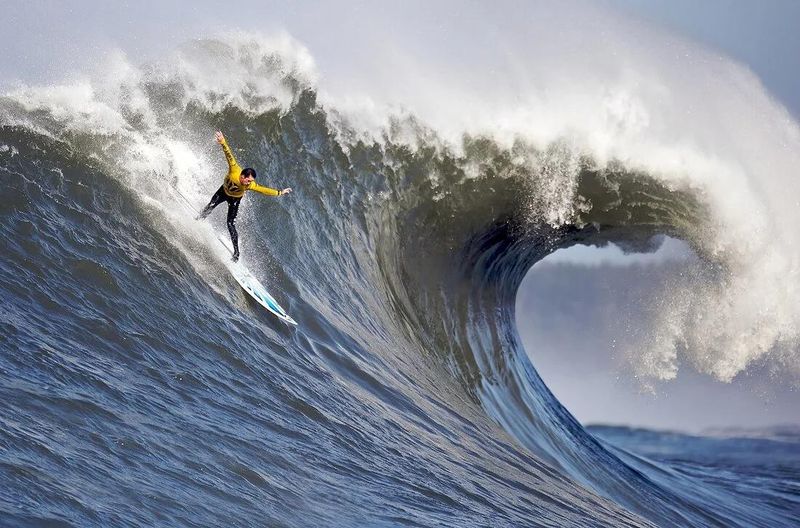
HALF MOON BAY, California, November 15, 2026 — A California high surf warning of a severity the coast sees only a handful of times in a decade held every Pacific beach in the state through the night into Sunday, as a massive long-period swell arrived with breaking waves of 25 to 35 feet and occasional sets of 40 to 50 feet at favored breakpoints like Mavericks. The warning, issued by the National Weather Service in San Francisco, ran until 4:00 a.m. PST on Sunday, November 15, and its language was unusually blunt: dangerously large breaking waves, life-threatening sneaker waves and rip currents, and an instruction to the public that amounted to a single sentence — stay off rocks, jetties and the water’s edge, and never turn your back on the ocean. By Saturday morning the instruments were confirming the forecast in full: NOAA’s offshore buoys recorded significant wave heights above 30 feet at station after station, peaking at 32.8 feet off Monterey.
On shore, the swell announced itself the way these events always do: not as a single dramatic wave but as hours of relentless, building energy. In Pacifica, south of San Francisco, waves crashed over the seawall that protects the town’s beachfront streets, throwing spray across the promenade in front of houses built within a stone’s throw of the surf, under a Coastal Flood Advisory that ran until 6 p.m. Saturday. Eyewitness video from the coast on Saturday showed huge waves overtopping a concrete pier, water exploding across the deck in sheets. Video: eyewitness video And at Mavericks, the reef break off Half Moon Bay that has become the global shorthand for dangerous surf, the promised sets — 40 feet and more on the biggest waves — were there for the small fleet of big-wave surfers and safety skis willing to meet them.
The warnings, in full
Every Pacific beach, until 4 a.m. Sunday
The architecture of the official response tells you how seriously forecasters took this swell. The National Weather Service office in San Francisco — the forecast office for the Bay Area and the Monterey Bay coast — placed all Pacific coast beaches under a High Surf Warning until 4:00 a.m. PST Sunday, the highest tier of surf alert the service issues, reserved for events in which the surf itself is a life-safety threat. The headline numbers were breaking waves of 25 to 35 feet along the coast generally, with occasional sets of 40 to 50 feet at favored breakpoints — the reefs and points, Mavericks above all, where the shape of the seafloor focuses a swell’s energy into individual waves far larger than those breaking along an open beach. Layered under the warning, a Coastal Flood Advisory ran until 6 p.m. Saturday, covering the run-up and overtopping that pushes water over seawalls, into beachfront streets and across low-lying coastal roads at high tide.
The North Coast, under NWS Eureka
The warning net extended the full length of the state’s northern half. The National Weather Service office in Eureka warned of breaking waves of 22 to 30 feet on the North Coast — Del Norte, Humboldt and Mendocino counties — with its warning likewise running until 4 a.m. Sunday. That coastline is a different and in some ways more dangerous proposition than the Bay Area’s: rockier, more exposed, dotted with jetties and harbor entrances, and fronted by small communities where the ocean is a working waterfront rather than scenery. The hazard list was the same everywhere, and forecasters repeated it in the same order for a reason: sneaker waves first, because they kill more people on this coast than the surf itself; rip currents second, because a shorebreak of this size generates currents no swimmer can fight; and cold water, heavy surf and debris-filled whitewater behind them, turning a single mistake at the water’s edge into a rescue that may not be survivable.
What the buoys recorded
Forecasts can be argued with; buoys cannot. The NOAA buoy array off the California coast — the instruments forecasters use to verify a swell’s arrival in real time — spent Saturday morning recording numbers that would headline any winter. These are the peak significant wave heights reported on the morning of Saturday, November 14.
| Buoy | Location | Peak significant wave height |
|---|---|---|
| 46042 | Monterey (offshore Monterey Bay) | 32.8 ft |
| — | Point Arena | 32.5 ft |
| — | Point Reyes | 31.2 ft |
| — | Bodega Bay | 30.8 ft |
Two points of context turn those numbers from statistics into a measure of the event. The first is what “significant wave height” means: the average of the highest third of waves passing the buoy. The largest individual waves are substantially bigger — in a long-period swell, the biggest can approach one and a half to two times the significant height. A buoy reading of 32.8 feet is therefore entirely consistent with the forecast call of 40- to 50-foot faces at the breaks where the swell focuses; the buoys sit miles offshore in deep water, measuring the swell before the seafloor gets its hands on it. The second point is the company the numbers keep. Readings above 30 feet at four buoys at once — Monterey, Point Arena, Point Reyes and Bodega Bay, all over that line on the same morning — mark a swell that is not a local accident of wind but a basin-scale event, hundreds of miles wide, arriving along the whole coast simultaneously. That breadth is why the warning map had no gaps in it.
What drove the swell
Analysis. A swell like this one is manufactured days earlier and thousands of miles away. The recipe, which National Weather Service forecast discussions return to whenever the North Pacific produces a headline event, starts with a powerful storm system in the North Pacific — a deep low-pressure center whose winds blow hard, for a long time, over a long stretch of open ocean. Wind speed, duration and that stretch of water, which meteorologists call fetch, are the three ingredients of wave size, and the great winter storms of the North Pacific max out all three. The waves then sort themselves on the journey toward California: the longest, fastest waves outrun the rest and arrive as a long-period swell, sets separated by long lulls, with periods that can approach twenty seconds. Period is the quiet variable that separates a merely big day from a dangerous one. A long-period swell carries far more energy per wave than short-period chop of the same height, and it is that energy, delivered in pulses, that produces both the giant faces at the reefs and the sneaker waves that arrive after minutes of deceptive calm.
The last step in the chain happens in the final few hundred yards, and it is geography. As a deep-water swell feels the bottom and slows, its energy compresses and the wave stands up — and where the bottom is shaped like a lens, as it is at Mavericks, where a reef system off Pillar Point funnels incoming energy onto a small takeoff zone, the result is a wave far bigger than the beach a mile away will ever see. That focusing is why the warning’s two numbers — 25 to 35 feet generally, 40 to 50 at favored breakpoints — can both be true of the same swell on the same morning. It is also why one coastline can be, at the same moment, a world-class sporting venue at one reef and a flooding emergency at the next town’s seawall: the ocean delivers one event, and the seafloor decides, place by place, what form it takes.
Why this matters
Water over the seawall: flooding and erosion
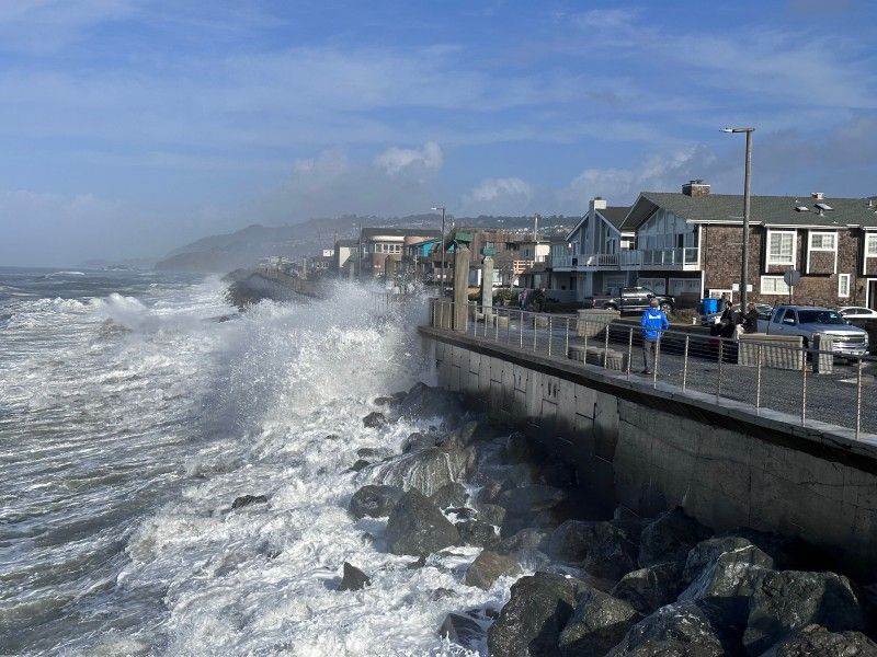
Start with the water where it is not supposed to be. The Coastal Flood Advisory that ran until 6 p.m. Saturday existed because a swell of this size does not respect the line where the beach ends. Wave run-up — the rush of water up the beach after a breaker lands — scales with the energy of the incoming sets, and when run-up coincides with high tide it overtops seawalls, floods the streets and lots behind them, and turns beach stairs and promenades into spillways. Pacifica, where waves were crashing over the seawall on Saturday, is the Bay Area’s standing example of the exposure: a town whose Sharp Park and Esplanade frontages have spent decades in a running argument with the Pacific, losing pieces of bluff, sidewalk and roadway in big winters and rebuilding behind armor rock and concrete. Every event like this one reopens that argument with fresh evidence, because the same waves that flood a street on Saturday are also doing slower work — undercutting bluffs, stripping sand from beaches that take months to rebuild, and testing every seawall and cliff-top home on the coast at once. The damage assessment that follows a swell is therefore never only about the water that got in. It is about the margin that got thinner.
Sneaker waves: the coast’s quiet killer
The deadliest phrase in the warning was not “50 feet.” It was “sneaker waves.” A sneaker wave is a disproportionately large wave that arrives without warning after a lull — sometimes ten, twenty, thirty minutes of surf that looks manageable — and runs much farther up the beach or rocks than anything before it. On the Northern California coast, sneaker waves have a long and grim record: they are the mechanism behind a large share of the ocean drownings that happen here year after year, sweeping people off rocks, jetties and dry sand — anglers, dog-walkers, photographers, parents standing with children at what looked like a safe distance — and pulling them into cold, violent water from which self-rescue is rarely possible. The National Weather Service offices on this coast have built entire warning campaigns around the phenomenon, and the instructions never change because the physics never does: the lull is part of the trap, the biggest wave of the hour may arrive when everyone has relaxed, and the only reliable defense is distance — off the rocks, off the jetties, back from the water’s edge, for the whole event and not just while the surf looks impressive. A warning running until 4 a.m. is also, deliberately, a warning about the night hours, when a black ocean gives no visual warning at all.
The two crowds: surfers and spectators
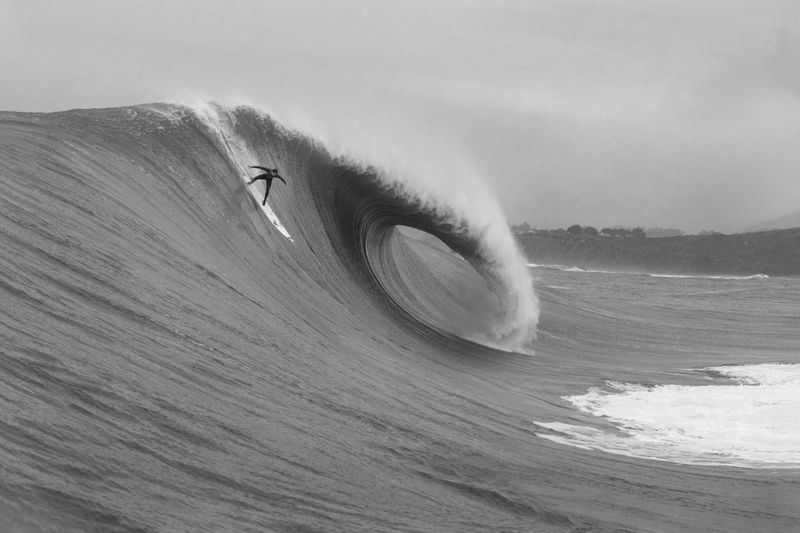
Every California mega-swell draws two crowds, and they want opposite things from the same ocean. The first is the big-wave community, for whom a forecast like this weekend’s is the reason for existing. Mavericks only truly works on the largest swells of the winter, and its modern history is written in events of exactly this class — and in their costs. The break claimed the life of Mark Foo, one of the sport’s pioneers, in 1994, and of Sion Milosky in 2011, two deaths that bookend the era in which Mavericks went from a rumor guarded by a handful of locals to the most famous big-wave venue on earth. The surfers who paddle or tow into 40-foot sets there today do so inside a safety culture built from those losses: flotation vests, trained water-safety crews on jet skis, spotters, and a hard-earned understanding that the wipeout, not the ride, is the event being survived. Their presence on a warning day is not recklessness in the simple sense; it is the point of the sport. But it depends entirely on preparation no casual observer shares.
The second crowd is everyone else, and it is the one lifeguards, harbor patrols and harbormasters spend these weekends managing. Big surf is a spectacle, and spectators come — to the bluffs above Mavericks, to the seawall in Pacifica, to piers, jetties and rock outcrops up and down the coast — very often standing precisely where the sneaker-wave record says not to stand. The coast has a canonical lesson in what happens next: during a Mavericks contest in 2010, a rogue set swept through the spectator area on shore and injured onlookers who believed they were watching from safety. The arithmetic has not changed since. A spectator has no wetsuit, no flotation, no safety ski, and usually no idea that the dry rock under their feet is dry only between sets. That is why the warning’s public language is aimed over the surfers’ heads at the shoreline crowd — and why lifeguard agencies and harbormasters treat a forecast like this one as a staffing emergency, pre-positioning rescue watercraft, extending patrols and closing the access points where the two crowds would otherwise meet the same wave with very different equipment.
The view from the coast
For the people who live with this ocean rather than visit it, a swell like Saturday’s is measured in smaller units than feet. In Pacifica it is measured in whether the water came over the wall at your street, whether the promenade is sand or whitewater, whether the drains can take what the surf delivers at high tide. Coastal residents learn to read these events the way farmers read weather — by tide tables and buoy graphs, by which sets are reaching the rocks only the biggest swells touch — and the experienced ones were not surprised by Saturday: the buoys had been building for days, the warning had been up in time, and the town’s weekend took its familiar shape, beachfront streets watched at high tide and promenade crowds kept, mostly, behind the rail. On the North Coast, harbormasters faced the working version of the same problem: harbor entrances and river bars, at places like Crescent City, Humboldt Bay and Noyo, where a 22- to 30-foot swell turns the crossing into or out of port into the most dangerous maneuver in commercial fishing, and where keeping a fleet tied up is measured in lost days at the height of the season. Their version of the warning is not a headline; it is a bar restriction, a closed entrance, a crew told to wait — and it holds until the swell, not the clock, says otherwise.
How this compares
Analysis. California has a reference shelf for events like this, and Saturday’s swell earns its place on it. The modern benchmark remains the winter of 2022–23, when a parade of atmospheric rivers paired with large swells to tear at piers, flood coastal towns and accelerate years of erosion into a single season; and the high-surf episodes of late December 2023, when another powerful swell sent enormous waves into Ventura and Santa Cruz county beaches, injuring onlookers and reminding the state that its most damaging coastal days are often sunny ones, when the storm is a thousand miles away and only the energy arrives. This weekend’s event belongs to that second family — a swell-driven, not storm-driven, emergency — but its buoy signature sits at the top of the range: peak significant wave heights of 30.8 to 32.8 feet across four stations at once, with forecasters calling for 40- to 50-foot sets at the best breaks, is a combination even strong El Niño winters do not produce every year. What distinguishes it, finally, is breadth. A swell that puts the whole coast from Del Norte to Monterey under simultaneous warnings, floods seawalls in the Bay Area and fires the state’s most famous big-wave break on the same tide is not a local story with a big number attached. It is the North Pacific, for one weekend, arriving all at once.
What happens next
The first thing that happens next is more of it. Forecasters had a second large swell arriving late Sunday through Monday, on the heels of the first — a sequencing that matters more than the raw numbers, because a coast does not reset between swells. Beaches stripped of sand by the first event offer the second a clearer run at the seawall; bluffs undercut over the weekend face the follow-up sets at their weakest; and the public’s attention, the real protective system on a warning weekend, is at its lowest exactly when the second swell arrives, on a workday, after the headlines have moved on. The warnings may be extended or reissued to cover it, and the advice will be identical, because the hazards will be: sneaker waves, rip currents, and water where people do not expect it. Anyone treating Sunday’s 4 a.m. expiry as an all-clear will have misunderstood what expired. It was the first swell’s warning. The ocean’s schedule runs longer.
Then comes the accounting. Once the second swell passes, the assessment phase begins: lifeguards, harbor patrols and the Coast Guard tallying rescues and close calls; cities and counties walking their seawalls, piers, stairs and bluffs to log what moved, cracked or disappeared; state parks and coastal agencies checking the beaches and access points that take the worst of every big winter; and homeowners along the exposed frontages beginning the slower argument about what this weekend cost and what the next one will. Some of that accounting will be quick and some will run for months, in permit files and seawall hearings in towns like Pacifica, where this weekend’s photographs — water over the wall, again — become exhibits in a debate about the coast’s future that California has conducted, one storm at a time, for forty years. For now, the record of the weekend stands where the instruments left it: four buoys above thirty feet, a warning that covered every Pacific beach in the state, sets at Mavericks worthy of the break’s legend, and a second swell already on the chart. The coast has been reminded, in the most literal terms available to it, what it is built next to.
Related coverage: Hurricane Rachel Turns Toward Southern California: 15-Foot Surf, Flood Risk and the End of Record Heat · Laguna Beach Flooding, October 2026: PCH at Broadway Under Water as Hurricane Rachel Swells Slam Orange County · Tropical Storm Rachel Batters Long Beach — Boardwalk Destroyed, Home on Brink of Collapse as Newport Beach Floods
Sources
National Weather Service, San Francisco Bay Area / Monterey forecast office (weather.gov/mtr) — High Surf Warning for all Pacific coast beaches until 4:00 a.m. PST Sunday, November 15, 2026 (breaking waves 25 to 35 feet; occasional sets of 40 to 50 feet at favored breakpoints such as Mavericks), Coastal Flood Advisory until 6 p.m. Saturday, November 14, and the associated forecast discussion. National Weather Service, Eureka — High Surf Warning for the North Coast (Del Norte, Humboldt and Mendocino counties), breaking waves 22 to 30 feet, until 4 a.m. Sunday. NOAA National Data Buoy Center — buoy reports for the morning of Saturday, November 14, 2026: Monterey buoy 46042 (ndbc.noaa.gov/station_page.php?station=46042) peaking at 32.8 feet significant wave height; Point Arena 32.5 feet; Point Reyes 31.2 feet; Bodega Bay 30.8 feet; and the forecast of a second large swell late Sunday through Monday. Eyewitness video of waves overtopping a pier on the California coast, Saturday, November 14, 2026. Video: eyewitness video Historical background on Mavericks and California high-surf episodes is drawn from the public record of the break and of the winters of 2022–23 and December 2023; where this report describes risk and mechanism in general terms, it reflects the standing guidance of the National Weather Service on sneaker waves and rip currents.