US · Weather
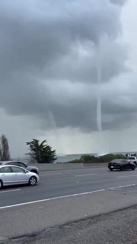
Two waterspouts spun side by side over San Francisco Bay near Candlestick Point late Monday morning, drawing a National Weather Service special marine warning as drivers on Highway 101 slowed to watch. Both funnels dissipated without making landfall, and no damage or injuries were reported.
Track it live: severe weather across the United States is updated in real time on our live severe-weather tracker.
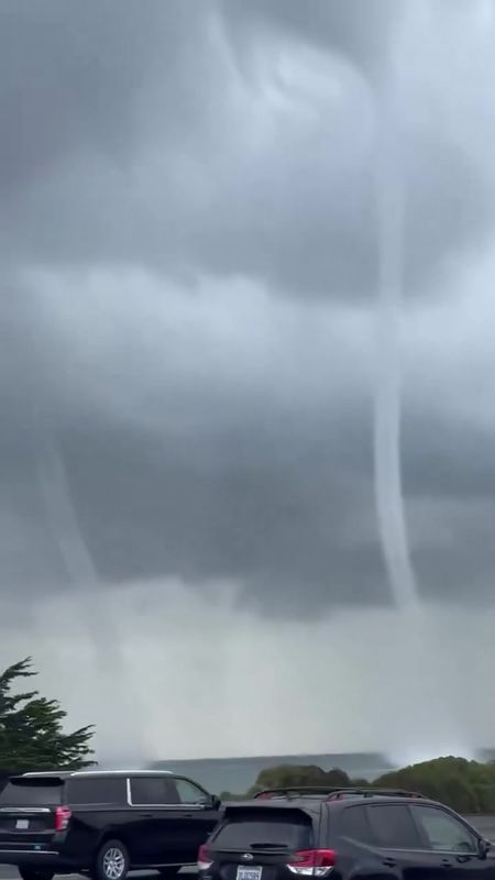
SAN FRANCISCO, November 16, 2026 — Two waterspouts formed at the same time over San Francisco Bay late Monday morning, spinning side by side near Candlestick Point while drivers on Highway 101 watched from the freeway below. The National Weather Service issued a special marine warning for the bay as the pair crossed the water. Both funnels dissipated without making landfall, and no damage or injuries were reported.
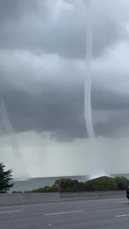
It was the kind of sight the Bay Area almost never gets: not one funnel, but two, hanging out of the same storm clouds at the same moment — a tall, well-defined spout reaching from the cloud base to the water, and a slimmer second funnel turning beside it. Video recorded from the highway between about 11:42 and 11:45 a.m. shows traffic slowing as drivers took in the pair, the bay grey and choppy beneath them, the shoreline north of San Francisco International Airport in the distance.
What the National Weather Service says
Around noon, the National Weather Service issued a special marine warning for San Francisco Bay south of the Bay Bridge, reporting that a thunderstorm over the water was producing waterspouts. Special marine warnings are the Weather Service's short-fuse alert for hazardous conditions on the water — the marine counterpart of the severe thunderstorm warnings issued over land — and mariners in the warned area were advised to move to safe harbour until the storm passed.
The episode was over quickly. National Weather Service meteorologist Roger Gass told SFGATE that the pair dissipated without making landfall. Just as important is what officials have not said: the precise classification of the two funnels has not been confirmed publicly, and the Weather Service has published no wind-speed or size estimates for them. Any account that assigns the pair a type, a rating or a wind speed is going beyond the official record.
What is a waterspout?
A waterspout is a rotating column of air that connects the base of a cloud to the surface of the water. The visible funnel is mostly condensed water vapour, while the vortex kicks up a spray ring where it meets the surface — which is why, from a distance, a waterspout can look as though the water itself is climbing into the sky.
Meteorologists generally describe two kinds. Fair-weather waterspouts form over relatively calm water beneath growing cumulus clouds, usually in light winds; they build upward from the surface, tend to be the weaker type, and often dissolve quickly. Tornadic waterspouts are born inside severe thunderstorms — in structure they are tornadoes that happen to be over water — and they can be significantly more dangerous, including if they move ashore. Those are general descriptions of two recognised categories. Which category Monday's pair belonged to has not been confirmed, and this article does not guess: the honest answer, on the current record, is that forecasters have not said.
Why the bay so rarely sees them
Waterspouts are common in some waters — the Florida Keys see them by the dozen in summer — but San Francisco Bay is a different environment. Its water stays cold all year, and a waterspout needs a particular stack of ingredients at once: moist air near the surface, cooler and unstable air above it, and enough low-level spin for a vortex to organise. Most Bay Area storms deliver one or two of those, not all three.
On Monday, the storm system moving through Northern California delivered the full set at the same place and time: a vigorous thunderstorm cell parked over the bay south of the Bay Bridge, unstable air behind the system's cold front, and the kind of shifting low-level winds that can stretch a small rotation into a funnel. Getting two funnels out of the same cell at the same moment is rarer still — which is why so many phones came out on Highway 101, and why the footage travelled so fast.
One piece of a much bigger storm
The waterspouts were the most photogenic part of Monday's weather, but they were only one piece of it. The same storm system triggered a rare tornado warning for Santa Cruz County — a warning for land, separate from the marine warning on the bay — which remained in effect until about 1:30 p.m. Tornado warnings are uncommon anywhere in coastal California, and Monday's underlined how unstable the atmosphere over the region had become.
At San Francisco International Airport, the rain and poor visibility piled up roughly 280 flight delays, according to CBS — the airport sits just south of where the waterspouts spun, and Monday's cell traffic, low cloud and wet runways slowed the operation through the middle of the day. Along the coast, the surf built through the day: a high surf advisory runs until 4 a.m. Tuesday, with breaking waves of 20 to 25 feet expected on exposed beaches — the kind of surf that keeps lifeguards busy and should keep everyone else well back from the water.
Why this matters
A pair of waterspouts that harms no one can look like a curiosity — a strange photograph and nothing more. But Monday's funnels are a data point about the Bay Area's weather, not just a spectacle. The same instability that spun up two waterspouts also produced a tornado warning on land, hundreds of flight delays and dangerous surf, all inside a few hours. Coastal California's severe weather usually arrives in that bundled form: no single catastrophic event, but a system that stresses the airport, the beaches, the freeways and the bay at the same time.
There is also a forecasting lesson in how the episode ended. The Weather Service saw the thunderstorm, warned the water, and the spouts behaved the way the warning framework assumes — they stayed over the bay and died there. The system worked. But the margin is the story: had a tornadic waterspout of the stronger kind come ashore at Candlestick Point or crossed the airport shoreline, Monday would be remembered very differently. That is why the classification question matters, and why it is worth waiting for the Weather Service's own answer rather than filling the gap with a confident guess.
What happens next
California is not done with this pattern. An atmospheric river is expected to bring more heavy rain to the state by midweek, reloading the same hazards Monday previewed: slick freeways, more flight delays at SFO, high surf, and the possibility of further waterspouts and short-lived spin-ups along the coast while the air mass stays unstable. Boaters should treat marine warnings as hard boundaries, beachgoers should respect the surf advisory through Tuesday morning, and anyone travelling through SFO midweek should expect the delays to come back with the rain.
For a few minutes on Monday, though, the storm offered the bay something it almost never sees — two white funnels turning over grey water, close enough to watch from a freeway. No one was hurt, nothing was damaged, and by the time the marine warning expired the sky over Candlestick Point was just sky again. The video is what remains: proof that even one of the most forecast, most modelled bays in America can still surprise the people driving past it.
Reporting based on the National Weather Service's special marine warning for San Francisco Bay (Monday, around noon) and statements by NWS meteorologist Roger Gass reported by SFGATE; additional reporting by Surfer, the New York Post and CBS. The classification of the two funnels has not been confirmed publicly by the National Weather Service, and no wind-speed or size estimates have been published; this article states neither. Flight-delay figures are CBS's count for SFO on Monday.
Sources
National Weather Service, special marine warning for San Francisco Bay south of the Bay Bridge (Monday, around noon) and statements by NWS meteorologist Roger Gass, via SFGATE · Surfer, reporting on the waterspouts and the marine warning · New York Post, twin waterspouts near Candlestick Point, north of San Francisco International Airport, late Monday morning · CBS, roughly 280 flight delays at SFO amid rain and poor visibility · Owner-supplied watcher video, Highway 101, Brisbane/Candlestick Point vantage, both spouts visible about 11:42–11:45 a.m. PT.