Philippines China Batanes dispute
Philippines China Batanes Dispute Escalates as Manila Rejects Beijing Claim

MANILA — The Philippines China Batanes dispute is not a routine extension of the quarrel over Scarborough Shoal or Second Thomas Shoal. It is a new argument over where the map of the confrontation begins. On October 2, the Philippine Department of Foreign Affairs firmly rejected the Chinese Embassy’s assertion that China held sovereign rights and jurisdiction in waters off Batanes. The immediate trigger was the research and survey vessel Jia Hai Ke 7, detected roughly 37 nautical miles northwest of Itbayat — a location Manila describes as well within its 200-nautical-mile exclusive economic zone.
The Philippine Coast Guard said it monitored the ship for days, repeatedly challenged it by radio and conducted law-enforcement operations that ultimately drove it north. Beijing’s account was the opposite. On October 1, Chinese Embassy Deputy Spokesperson Guo Wei said the vessel was carrying out “normal operations in waters under China’s jurisdiction,” accused the coast guard of harassment and warned that China would continue taking resolute measures to defend what it called legitimate rights and interests.
The words matter because Beijing did not publicly explain the geography behind its jurisdiction claim. Instead, it invoked provisions of the United Nations Convention on the Law of the Sea dealing with overlapping entitlements and negotiation. Manila answered with a more immediate rule: marine scientific research in another coastal state’s EEZ requires that state’s consent, and no request was received and no consent was given.
The South China Sea contest has been severe but geographically familiar. Chinese pressure, Philippine patrols and U.S. alliance signaling have converged around features west of Palawan and Luzon: the Spratly Islands, Second Thomas Shoal, Scarborough Shoal and the routes between them. Batanes is different. It is the Philippines’ northernmost island province, placed in the Luzon Strait between the main island of Luzon and Taiwan. A claim here pulls the dispute beyond the West Philippine Sea and into the corridor most sensitive to any Taiwan emergency.
That makes this a qualitative escalation. A collision at a contested shoal can still be framed, however dangerously, as part of a long-running sovereignty argument around reefs and rocks. A research vessel operating 37 nautical miles from Itbayat raises a broader proposition: that China may assert maritime jurisdiction in northern Philippine waters even where the familiar nine-dash-line narrative supplies no obvious public explanation. If repeated, the incident would normalize a second pressure zone on Manila’s map.
Batanes lies about 190 kilometers south of Taiwan. The waters around it connect the South China Sea, the Philippine Sea and the western Pacific. Merchant shipping, naval movements and undersea communications all pass through or near this strategic aperture. In a Taiwan contingency, the Luzon Strait would be a route for submarines, surface forces, aircraft and logistics. Hydrographic knowledge of that corridor is therefore not merely academic. It can shape military planning, anti-submarine operations and the safety of navigation.
The first-order question is legal: did the vessel have permission? The second is strategic: why test the boundary here, now? The third is political: can Manila resist a new front without allowing every survey encounter to become a military crisis? Those questions make the Batanes incident larger than the ship itself.
What happened off Itbayat
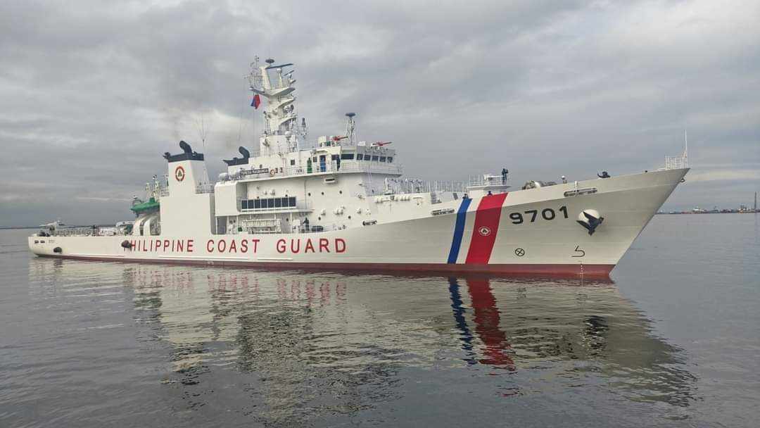
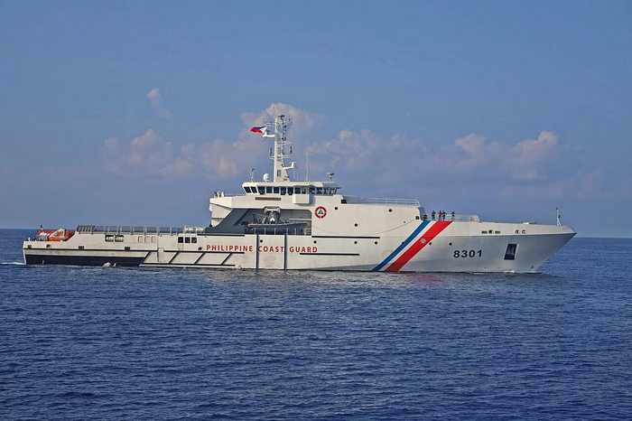
According to the Philippine account summarized by BusinessMirror, the coast guard tracked Jia Hai Ke 7 for several days after it was detected northwest of Itbayat. Philippine officers treated its activity as suspected unauthorized marine scientific research rather than innocent passage. A coast-guard vessel moved close enough to issue radio challenges, while an aircraft supported monitoring. The research ship did not answer those challenges, Philippine officials said, and later moved north.
Balitang Marino reported that the Chinese ship departed around noon on October 2, accompanied by China Coast Guard vessel 2503. Rear Adm. Jay Tarriela credited the crew of BRP Teresa Magbanua and the coast-guard Islander aircraft with disrupting the operation. That escort detail is strategically important: the arrival of an official Chinese coast-guard ship connected a nominally civilian or private research mission to state power.
Guo’s October 1 statement accused the Philippine side of endangering Chinese vessels and personnel. China said the operations complied with international law, including UNCLOS. Manila’s October 2 reply said its coast guard was performing lawful and routine law enforcement inside the Philippine EEZ. Each capital therefore portrayed itself not as the escalator but as the defender of a settled legal order.
The dates compress the diplomatic escalation into less than 48 hours: Beijing asserted jurisdiction on October 1; Manila rejected that assertion on October 2; and operationally, the ship had already been challenged and driven from the area. The speed suggests that neither side regarded this as a technical permitting dispute.
The legal duel: Article 246 against Articles 74 and 83
Manila’s clearest argument rests on Article 246 of UNCLOS. Paragraph 2 says marine scientific research in a coastal state’s exclusive economic zone and on its continental shelf shall be conducted with that state’s consent. The convention generally encourages peaceful research, and coastal states should not unreasonably delay or deny ordinary projects, but the procedural starting point is still notification and permission. The DFA said no Chinese request arrived and no consent was granted.
That is why the distance matters. Thirty-seven nautical miles is less than one-fifth of the 200-nautical-mile outer limit of an EEZ. Distance alone does not resolve every maritime-boundary question, especially where coasts face one another and entitlements can overlap. But China must still identify the competing coast and the line of entitlement that produces its claimed jurisdiction. Its public statement did not do so.
Beijing cited Articles 74 and 83, which govern delimitation of overlapping EEZ and continental-shelf claims and call for agreement on an equitable basis. China also referred to a supposed consensus that disputes should be settled through negotiation. Those provisions matter when two lawful entitlements overlap. They do not automatically authorize one side to conduct research in the disputed zone without explaining the overlap or seeking consent.
The legal gap is therefore not simply that Manila and Beijing read UNCLOS differently. It is that Manila offered a measured location, a coastal baseline and a consent rule, while Beijing publicly offered a conclusion — “waters under China’s jurisdiction” — without the geographic chain connecting that conclusion to the vessel’s position. Negotiation is a process, not a source of jurisdiction by itself.
The 2016 arbitral tribunal ruling in the Philippines’ case against China makes the unexplained claim harder to sustain politically. The tribunal rejected the legal basis for expansive Chinese historic-rights claims within the nine-dash line where they exceeded rights available under UNCLOS. China rejects that award, but the decision remains binding between the parties under the convention’s dispute-settlement framework. A northern claim cannot escape that history merely by moving away from the shoals named in the original case.
From West Philippine Sea to Luzon Strait
For a decade, Manila’s public diplomacy has centered the phrase “West Philippine Sea.” That framing helped translate complex law into a domestic geography: waters to the west where Filipino fishermen, coast-guard crews and resupply missions confronted Chinese pressure. Batanes changes the compass. A northward challenge asks the Philippine government to defend a maritime perimeter that connects the Taiwan Strait to the Philippine Sea.
Beijing may see advantage in that shift. If Manila accepts an “overlap” label before China explains its entitlement, the premise of negotiation moves in China’s favor. What had been treated as ordinary Philippine EEZ becomes a zone requiring bilateral management. The research voyage can thus operate as a diplomatic probe: not only gathering data, but testing whether repetition can produce an expectation of access.
Manila’s firm language was designed to block that normalization. The DFA did not merely say the vessel lacked a permit; it rejected the embassy’s assertion of sovereign rights and jurisdiction. Tarriela went further, telling Guo to stop meddling and promising continued removal of unauthorized research ships. Those statements raise the reputational price of any future Philippine decision to tolerate similar operations.
Gray-zone science and dual-use data
Scientific vessels sit in a useful gray zone. Their equipment maps seabed contours, currents, salinity, temperature and acoustic conditions. That information has genuine civilian value for climate studies, fisheries, earthquake research, cable planning and safe navigation. The same data can also refine submarine routes, sonar performance, mine warfare and the placement of sensors. The label “research” does not settle the purpose of the collection.
This does not mean every hydrographic voyage is espionage. It means coastal-state consent is strategically meaningful precisely because the data can be dual use. A survey ship can gather knowledge that a navy later exploits without carrying weapons or flying a naval ensign. When a state research platform operates near a militarily sensitive strait under coast-guard protection, planners will assume at least some of the resulting information may enter defense systems.
Regional precedent reinforces the concern. Across the South China Sea and western Pacific, research and survey vessels have spent extended periods tracing grids near other states’ energy blocks, undersea features and maritime approaches. These missions create facts through presence while remaining below the threshold that would normally trigger military retaliation. The pattern is classic gray-zone statecraft: enough pressure to change behavior, not enough force to justify war.
The operational response also shows the constraint. The Philippine Coast Guard, not the navy, took the lead. That kept the encounter in the law-enforcement domain and denied Beijing an easy argument that Manila militarized a scientific mission. Yet coast-guard crews at close range still face collision, miscalculation and escalation risks. Gray-zone tactics are dangerous because they transfer strategic contests into tactical spaces where a captain has minutes to decide.
Manila’s internal split: advocate and diplomat
The dispute also exposes a real difference inside the Philippine government. Defense Secretary Gilberto Teodoro Jr. described himself as an “advocate, not a diplomat” in resisting unlawful interference. Foreign Secretary Theresa Lazaro has kept channels open and emphasized dialogue. Teodoro acknowledged friction between their approaches. That is not necessarily dysfunction; defense and diplomacy are supposed to apply different instruments. But Beijing will study whether the difference becomes a seam it can exploit.
The hawkish case is straightforward. Repeated accommodation can convert exceptional intrusions into routine access. If the coast guard fails to challenge a ship today, China may cite that silence tomorrow as evidence of toleration. Teodoro’s advocates therefore treat firmness as preventive: visible enforcement now reduces the risk of a larger coercive campaign later.
The diplomatic case is equally practical. China is a major economic partner, a permanent neighbor and an unavoidable participant in regional security. Every encounter cannot be allowed to close communication. Lazaro’s approach preserves the ability to clarify claims, establish protocols and prevent a vessel confrontation from contaminating the entire relationship. Dialogue is not concession if the legal position remains clear.
The strongest strategy combines both: coast-guard enforcement that prevents normalization, paired with diplomatic contact that demands coordinates, legal reasoning and prior-notification rules. The weakest strategy would alternate between maximal rhetoric and quiet tolerance, leaving crews uncertain and allies doubtful. Batanes will test whether Manila can make advocacy and diplomacy reinforce one another.
The United States alliance and EDCA’s northern geography
Washington will read the incident through two overlapping maps. The first is the U.S.-Philippines Mutual Defense Treaty, which both governments have repeatedly said applies to attacks on Philippine armed forces, public vessels and aircraft in the Pacific, including the South China Sea. The second is the Enhanced Defense Cooperation Agreement, under which the United States gained access to additional Philippine sites, including locations in northern Luzon positioned closer to Taiwan.
A research ship does not by itself activate a defense treaty. Nor does a coast-guard radio challenge create an automatic U.S. role. But the location matters to alliance planning. If Chinese coast-guard escorts and survey missions become persistent near Batanes, Manila may ask for more maritime-domain awareness, aerial surveillance and coast-guard support in the north. The United States would gain better warning but also face greater pressure to demonstrate that alliance assurances cover the new theater.
Beijing, for its part, may argue that U.S. access to northern Philippine sites is what militarizes the area. That narrative could be used to justify more Chinese monitoring. Manila will answer that EDCA activities occur by Philippine consent on Philippine territory, while Jia Hai Ke 7 conducted research without permission. The legal distinction is sharp; the security dilemma is still real. Each side interprets the other’s presence as the reason for its own.
Who gains, who loses
In the short term, the Philippine Coast Guard gains institutional credibility. It detected the ship, documented the encounter, challenged it and reported a departure without a collision. The DFA gains a clear legal case built around location and consent. Teodoro gains evidence for his argument that pressure is widening beyond traditional flashpoints.
China still gains information. Even an interrupted mission may collect valuable hydrographic data and test Philippine response times, aircraft availability and command procedures. Beijing also placed its jurisdiction claim into the public record. Future statements can refer back to it, gradually thickening a position that initially appeared unexplained.
The most exposed parties are local communities and commercial users of the Luzon Strait. Fishermen face uncertainty over enforcement boundaries. Shipping companies face higher insurance and routing concerns if coast-guard standoffs migrate north. Taiwan faces another layer of pressure around its southern approaches. And Manila faces the resource cost of patrolling a longer maritime frontier while still maintaining presence around western flashpoints.
What the numbers show
The numerical contrast is the simplest guide to Manila’s case: 37 nautical miles from Itbayat versus a potential 200-nautical-mile EEZ. The ship was roughly 163 nautical miles inside that outer limit when measured from the reported distance alone. Boundary law can modify simple circles, but Beijing has not publicly shown a competing coast or proposed line that places the vessel within Chinese jurisdiction.
The geographic contrast is equally important. Batanes sits approximately 190 kilometers south of Taiwan, far from the best-known Spratly flashpoints. An enforcement operation there requires different patrol patterns, air coverage and logistics. A coast guard designed around western incidents must now contemplate sustained northern deployments, potentially dividing ships and surveillance assets across two arcs.
The timeline — detection from September 28, a direct challenge on October 1, departure and formal Philippine rejection on October 2 — also shows that operational and diplomatic tracks moved together. That coordination is a strength. It makes it harder for either side to portray the confrontation as a misunderstanding discovered only after the fact.
Forward scenarios: four paths from Batanes
1. Repeated survey probes
The most likely scenario is repetition with variation. Another ship may return at a different coordinate, with a different declared purpose or with a larger coast-guard escort. Each mission would test whether Manila can sustain monitoring and whether international attention fades. China would not need to win a legal argument immediately; it would seek to make presence ordinary.
2. Coast-guard standoffs migrate north
A second path is the migration of familiar South China Sea tactics: blocking maneuvers, water cannons, dangerous approaches and competing radio warnings. The risk rises if vessels operate near fishing boats or in bad weather. Manila’s challenge will be to document coercion while keeping naval forces in reserve.
3. A negotiation-demand strategy
Beijing may use the asserted overlap to demand formal talks, then cite Manila’s participation as recognition that a dispute exists. The Philippines can discuss incident prevention without conceding jurisdiction, but its diplomats will need careful language. Technical talks on research notification may be useful; talks premised on an unexplained Chinese entitlement may not be.
4. Taiwan-contingency spillover
The most dangerous scenario is a wider Taiwan crisis. Survey data, coast-guard positioning and access around Batanes would then acquire immediate military relevance. Commercial traffic could face rerouting, undersea cables could become security concerns and U.S.-Philippine coordination in northern Luzon would intensify. A dispute that began as marine science could become part of a much larger theater.
Conclusion: the unanswered map
The Philippines has supplied a coordinate, a distance, a consent rule and an enforcement account. China has supplied a claim of jurisdiction, a reference to overlapping entitlements and a warning. What Beijing has not supplied publicly is the map that joins those elements together.
That omission is the center of the Philippines China Batanes dispute. If China can assert “overlap” without identifying the legal and geographic basis, then negotiation becomes a tool for manufacturing ambiguity where Manila says none exists. If the Philippines can repel each vessel but cannot sustain surveillance across the north, operational reality may outrun the law.
Batanes is not simply another dot in a maritime argument. It is the hinge between the West Philippine Sea, the Taiwan Strait and the Philippine Sea. The confrontation around Jia Hai Ke 7 shows that the hinge is now under pressure.
Sources
- BusinessMirror — China’s Batanes waters claim sparks new maritime row
- Balita — DFA rejects China’s claim over Batanes waters
- Asia Pacific Insights — Philippines rejects China’s claim to sovereign rights over Batanes
- ThePhilBizNews — Marine research off Batanes unauthorized
- Balitang Marino — PCG drives away Chinese research vessel from Batanes
- UNCLOS Part XIII — Marine scientific research, including Article 246