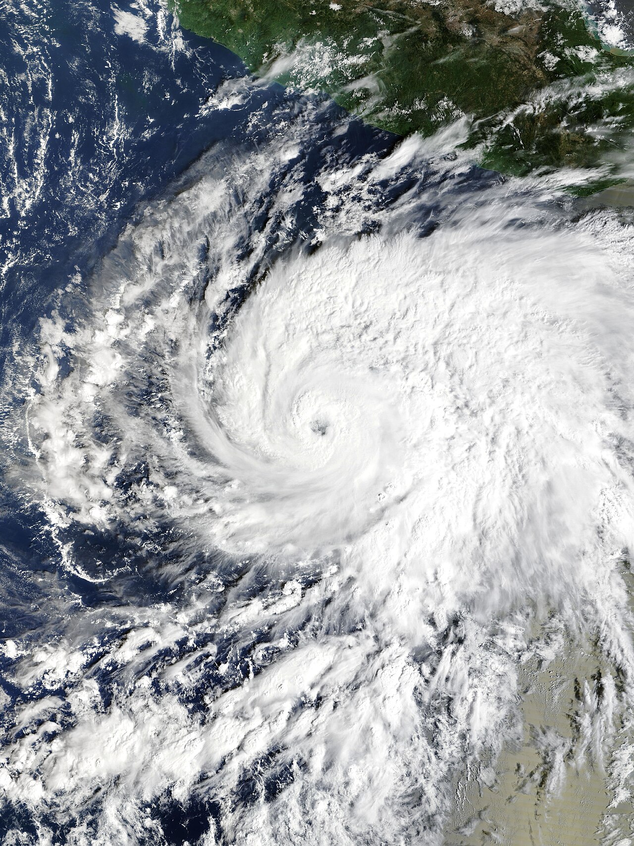
Weather / Hurricanes — The Hurricane Vance path kept bending north-northwest off Mexico’s Pacific coast on Friday night, October 23, after a full day of rapid strengthening took the storm from a new hurricane at 85 mph in the early morning to a Category 2 hurricane at 110 mph by evening — one step below major-hurricane strength, with forecasters still warning it could briefly reach Category 3 on Saturday even as they stressed how uncertain that call is.
Track it live: Follow Hurricane Vance and every active storm on the Signal Post News live hurricane tracker.
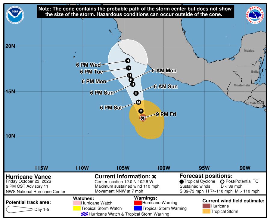
MIAMI — Hurricane Vance rapidly strengthened into a Category 2 storm on Friday as it neared Mexico’s Pacific coast, the National Hurricane Center (NHC) said. In its Advisory 11, issued at 9:00 p.m. CST on Friday, October 23, the center placed Vance near latitude 12.0 north, longitude 102.6 west, moving north-northwest at 7 mph, with a minimum central pressure of 965 millibars and maximum sustained winds of about 110 mph (177 kph) — described by the NHC itself as “near major hurricane strength.” Earlier in the day the Associated Press, citing the same advisory cycle, put the storm about 385 miles (620 kilometers) south-southwest of Acapulco. No coastal tropical cyclone watches or warnings were in effect as of Friday’s advisories.
That calm on the warnings map should not be mistaken for calm on the water. The NHC warned that swells generated by Vance are expected to begin affecting portions of southern and southwestern Mexico this weekend and continue into next week, and that those swells are likely to cause life-threatening surf and rip-current conditions. The hurricane’s outer bands were already funneling gale-force winds and rough seas into Mexico’s Gulf of Tehuantepec on Friday, the AP reported. Mexico’s national weather service, the Servicio Meteorológico Nacional (SMN), forecast locally heavy rainfall of 25–50 mm (1–2 inches) across central and southwestern Michoacán and coastal Guerrero, showers of 5–25 mm in Oaxaca, and waves of 2–3 metres (7–10 feet) along the Guerrero coast, advising residents and maritime operators to follow official Civil Protection guidance.
How Vance went from a named storm to near-major in two days
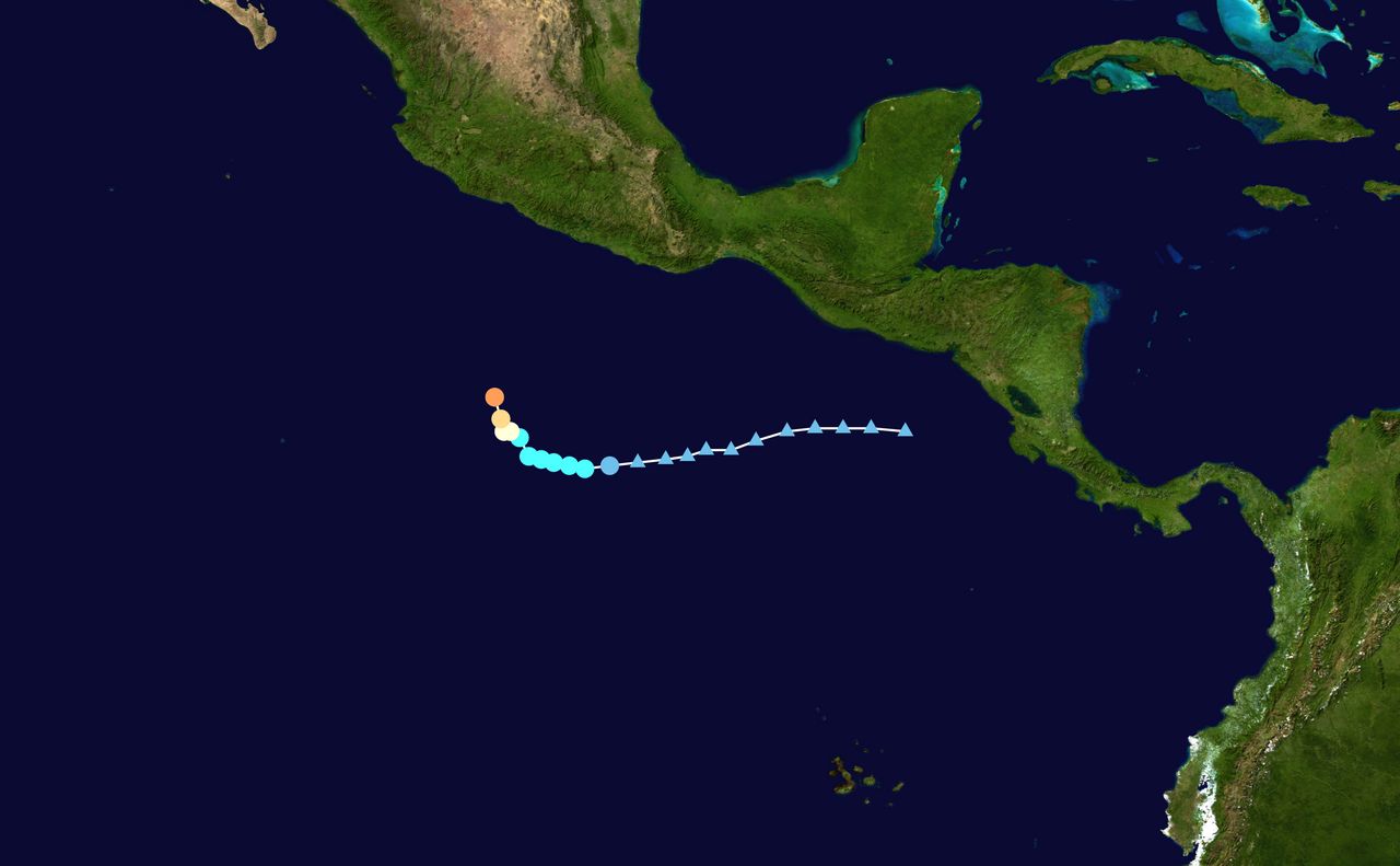
The Hurricane Vance timeline is a study in rapid intensification. The NHC began tracking an area of interest southwest of Mexico on October 18. It became Tropical Depression Twenty-Two-E on the afternoon of October 21 and intensified into Tropical Storm Vance soon after, about 520 miles south of Acapulco. By 3:00 a.m. CST on Friday, October 23, Vance had become a hurricane at 85 mph. At 9:00 a.m. CST it was at 90 mph and about 455 miles south-southwest of Acapulco, with a pressure of 979 millibars. At 3:00 p.m. CST it had reached 105 mph and 971 millibars. By 9:00 p.m. CST it stood at 110 mph and 965 millibars. In the 24 hours to Friday morning alone, its winds had climbed from 60 mph to 90 mph while its pressure fell from 997 to 979 millibars. Fox Weather noted that Vance strengthened into a hurricane early Friday, becoming the 13th hurricane in the Pacific basin this season, and that it is the first V-named storm in the eastern Pacific since 2018.
What the forecast actually says — and where it disagrees with itself
Read carefully, the official forecast contains two ideas at once, and both matter. The NHC forecast Vance to briefly reach Category 3 intensity — winds near 115 mph (185 kph) — around Saturday morning, before weakening back to Category 2 by early Sunday, October 25. The AP’s summary of the same guidance said gradual weakening was expected to start by Saturday. Those are not quite the same story, and the NHC was unusually candid about why: confidence in the intensity forecast is low. A NOAA drifting buoy that passed near the center measured a pressure of 988.5 hPa several hours before one advisory, nearby sea-surface temperatures were below 28°C, and Vance was approaching a pool of cooler water possibly produced by upwelling from recent tropical cyclones. Increasing southwesterly to westerly wind shear over the next 24 hours could interrupt the strengthening cycle, though some modest re-intensification is possible once Vance moves beyond the cold pool.
The track carries the same fork. Vance is expected to move slowly northwest or north-northwest through the weekend, but track uncertainty increases after two to three days. Forecast discussion summarized on Friday night explained the split plainly: a weaker, more vertically tilted system could be steered farther westward, away from land, while a stronger, vertically coupled hurricane would be more likely to continue northward toward the southwestern or west-central coast of Mexico. Some coverage on Friday, citing earlier NHC guidance, described the storm approaching the Puerto Vallarta area by Monday and weakening before it reaches the vicinity of the coast somewhere near Manzanillo next week. That is a scenario, not a promise — the distance between “weakens offshore” and “brushes the coast near Manzanillo” is exactly the distance the next two days of advisories have to close.
Why this matters
Vance matters less for what it has done — so far, no deaths, damage or landfall have been reported from this storm — than for what it reveals about the season Mexico’s Pacific coast is living through. The AP reported that if Vance reaches major-hurricane strength, it would be the seventh major hurricane in a row this year in the Pacific, following Nolo, Odalys, Polo, Rachel, Simon and Trudy. USA Today counted Vance as the 23rd named storm of the busy 2026 season in the northeast Pacific and noted it could become the fourth Pacific tropical system to make landfall in Mexico this year, depending on the track it ultimately takes. A season that produces major hurricanes in a queue, late into October, compresses the recovery time between storms: the same Guerrero and Michoacán coastline now watching Vance’s swell has already absorbed a season of rain, surf and saturated ground, which is precisely the condition in which a “near miss” storm can still flood roads and cut communities off.
There is a second, quieter lesson in the numbers. At 15:00 UTC on Friday, hurricane-force winds extended only about 35 miles from Vance’s center, while tropical-storm-force winds reached out as far as 205 miles. Vance is, by hurricane standards, a compact core wrapped in a very wide field of rough weather. That shape explains the apparent paradox of Friday’s coverage: a storm still hundreds of miles offshore, with no watches in effect, can already be pushing gale-force winds into the Gulf of Tehuantepec and sending dangerous surf toward beaches from Guerrero northward. For coastal Mexico this weekend, the sea is the hazard first, the wind second, and the rain — 25 to 50 millimetres in the SMN’s heaviest bands — third, unless the track bends closer to shore.
Background: an assembly-line Pacific season
The AP framed the wider pattern directly: it has been an intense hurricane season in the Pacific Ocean, with storms spawning in assembly-line fashion near Hawaii and Mexico as El Niño conditions, worsened by global warming, create unusual weather — the same pattern the agency linked to this week’s severe flooding and tornadoes in the southwestern United States and the prolonged drought in Central America’s Dry Corridor. Vance is arriving in the same week that Super Typhoon Champi, on the other side of the Pacific, shut down much of Taiwan — a pairing Fox Weather highlighted on Friday — and only days after Hurricane Trudy threatened Mexico’s coast under a hurricane warning. Coastal residents can be forgiven a sense of déjà vu; the forecasters’ job, and ours, is to keep each storm’s facts separate anyway, because the details — compact or sprawling, strengthening or shearing apart — are what decide who actually gets hurt.
What happens next
The next NHC advisories will answer three questions in order. First, does Vance cross the 111 mph line into Category 3 on Saturday morning, as the peak of the official forecast suggested, or does the cooler water and rising shear cap it at Category 2, as the low-confidence caveats warned? Second, does the center hold its slow north-northwest drift through the weekend, keeping the core offshore while the swell arrives, or does the stronger-storm branch of the guidance win and pull it closer to the coast between Manzanillo and Puerto Vallarta early next week? Third, do watches finally appear for part of the Guerrero, Michoacán, Colima or Jalisco coast — the moment when a forecast story becomes an instructions story for people who live there? Until then, the official advice is simple and specific: stay off the water where surf and rip currents are forecast, expect the heaviest rain in coastal Guerrero and southwestern Michoacán, and follow NHC and Mexican Civil Protection updates rather than any single model map circulating on social media.
Related coverage: Hurricane Trudy’s Category 3 threat to Mexico · Typhoon Champi shuts down Taiwan · Four Corners flooding and rooftop rescues
Sources
National Hurricane Center public advisories and forecast discussions for Hurricane Vance (Advisories 8–11, October 23, 2026), via NOAA/NHC advisory archive and The Watchers’ NHC summary; Associated Press, “Vance intensifies rapidly and could become a major Category 3 hurricane off Mexico’s Pacific Coast,” October 23, 2026, via The Reflector; USA Today, “Hurricane Vance forms, could become major system,” October 23, 2026; Fox Weather, October 21–23, 2026; Servicio Meteorológico Nacional (SMN/CONAGUA) rainfall and surf forecasts for Guerrero, Michoacán and Oaxaca, October 23, 2026, via The Watchers.