Weather / Disasters — Severe flooding across the Four Corners region on Friday forced water rescues — some of them from rooftops — closed roads and triggered emergency declarations from Colorado to the Navajo and Hopi nations, the Associated Press reported. In South Fork, Colorado, mandatory evacuations stayed in force after the Rio Grande and local creeks overtopped their banks; in Dennehotso, Arizona, rescuers brought seven families — 30 people in all — out of flooded homes; and forecasters warned the threat would shift into New Mexico and West Texas into Saturday morning, with rainfall rates that could exceed two to three inches an hour.
Track it live: Live severe weather and tornado tracker
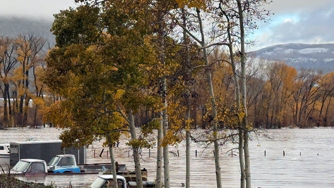
SOUTH FORK, Colo. — The Four Corners is a landscape built around dry washes, red rock and rivers that are supposed to stay in their banks. This week they did not. Severe flooding on Friday led to water rescues — some from rooftops — and impassable roads across the region where Colorado, New Mexico, Arizona and Utah meet, with some residents told to evacuate low-lying areas of Colorado and New Mexico and others advised to shelter in place until water levels go down, according to the Associated Press.
Colorado Gov. Jared Polis verbally declared a state of emergency late Thursday in response to flooding across the southwestern part of the state, FOX Weather reported. Widespread flooding continued across South Fork on Friday, with mandatory evacuations remaining in effect after parts of the Rio Grande and local creeks overtopped their banks. The town of Pagosa Springs, near the New Mexico border, declared its own local state of emergency due to flooding.
No deaths had been confirmed in Friday’s flooding in the reporting available at publication. The National Weather Service separately warned of flooding it described as deadly along the Little Colorado River from Holbrook to Leupp in Arizona — language about the danger at low-water crossings, carried in full below — and officials across four states stressed that the most dangerous hours may still be ahead as the storm system moves east.
Tribal nations at the centre of the flood map
Some of the hardest-hit communities are tribal. Hopi leaders declared a state of emergency after persistent heavy rainfall and widespread flooding swept through northern Arizona, the Arizona Republic reported. Hopi officials said flash floods caused significant damage to bridges, roadways, homes, utilities, buildings and equipment across multiple communities, and that the storms also triggered mudslides and rockslides. The village of Lower Moenkopi issued its own emergency flooding declaration, and flooding was reported across a long list of Hopi communities from Upper Moenkopi and Hotevilla to Old Oraibi, Shungopavi, Walpi and Keams Canyon.
“The Hopi Tribe encourages all residents to prioritize their safety, remain informed about changing weather conditions, and take necessary precautions to protect their families and property,” Hopi Chairman Lamar B. Keevama and Vice Chairman Mikah H. Kewanimptewa Sr. said in an Oct. 22 advisory quoted by the Republic.
In the Navajo Nation community of Dennehotso, seven families — 30 people in all — were rescued from their flooded homes, Navajo police said. The rescues were coordinated with the Navajo Department of Emergency Management, Navajo Nation Fire and Rescue Services, Navajo EMS, the Navajo Department of Transportation, local chapter house personnel, Arizona DPS Rangers Air Rescue and the Kayenta Fire Department, and emergency officials deployed a SHERP all-terrain rescue vehicle. Dennehotso Loop Road was flooded and overtopped, and roads in various communities were closed because of washouts and heavy mud.
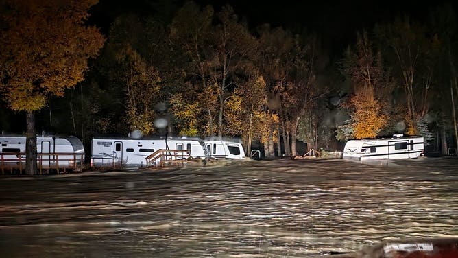
The disruption reached the basic machinery of daily life. Schools near the Arizona–Utah line were released early on Oct. 22, Chinle schools dismissed early on Oct. 21 and shifted to online learning, Tuba City declared a “mud day” closure on Oct. 23 — a weather closure for unpaved roads made unsafe for buses — and Ganado schools moved online. Sage Memorial Hospital in Ganado experienced power outages and flooding concerns on Oct. 22 while remaining open with limited services, and Tuba City Regional Health Care delayed outpatient clinics by three hours on Oct. 23. The Navajo Parks and Recreation Department closed Monument Valley Navajo Tribal Park and the Four Corners Monument for Oct. 21 and 22; both reopened on Oct. 23, along with Lake Powell Navajo Tribal Park, while the Monument Valley 17 Mile Loop Drive remained closed due to road damage and Lower Antelope Canyon was expected to stay closed on Oct. 24 as well.
A record river, a helicopter rescue and a 16-year first
The numbers explain why a desert region flooded so fast. In northern Arizona, the Moenkopi Wash near Tuba City reached a record-high level: the previous record was 29.79 feet, and by 7 p.m. ET Thursday the water had climbed to 32.48 feet — nearly three feet above it, FOX Weather reported. Four people were rescued by helicopter from the roof of a pickup truck surrounded by floodwaters near Rimrock, Arizona, on Thursday. Flash flooding also struck Hurricane, Utah, again on Thursday, where city officials said at least 130 homes and RVs were damaged and residents near Gould Wash were ordered to evacuate immediately.
The same system rewrote the region’s severe-weather record books. Arizona was placed under Tornado Watches on both Wednesday and Thursday — the first Tornado Watches issued in the state since October 2010 — and New Mexico received a Tornado Watch for the first time since 1998. The storms produced a 72-mph wind gust in Flagstaff, and National Weather Service crews were set to survey damage from a suspected tornado that struck Heber, Arizona, on Wednesday, where fire officials said one person was taken to hospital with non-life-threatening injuries. Severe weather began Wednesday as a powerful storm system pulled warm, moist Pacific air into Arizona, fuelling thunderstorms, large hail, damaging winds and flash flooding.
Why this matters
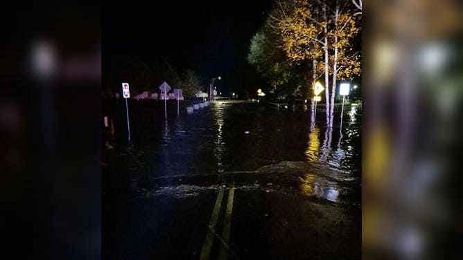
Desert flooding is dangerous precisely because the landscape is not built for water. Dry washes that are empty most of the year become rivers in minutes; unpaved roads turn to mud that strands school buses and ambulances alike; and low-water crossings — the places where roads dip through washes — are where drivers most often misjudge depth and current. A record crest nearly three feet above the previous mark on the Moenkopi Wash is not a marginal event: it means water reached places local memory said it would not reach, which is when familiar roads and familiar shortcuts become traps.
The tribal dimension compounds the risk. A study published Sept. 24 by the Urban Institute, cited by the Arizona Republic, found that tribes and Indigenous communities face disproportionate exposure to natural hazards including flooding: between 2015 and 2024, Indigenous communities in the United States and its territories experienced an estimated $4.4 billion in damage to property and crops from disasters — more than five times the FEMA disaster recovery grant funding they received over the same period, compared with about 1.2 times for non-Indigenous communities. More than half of Indigenous communities experienced two or more presidentially declared disasters in the past decade, the study found, and back-to-back disasters compound the damage because infrastructure is still destabilised when the next one arrives. That pattern is visible here in miniature: the Navajo Nation’s September flash flooding claimed three lives, President Buu Nygren approved an emergency declaration on Sept. 17 that remains in effect, and October’s water arrived before that recovery had closed.
There is also a forecasting story. Tornado Watches are so rare in this region — 16 years in Arizona, 28 years in New Mexico — that many residents have never had to act on one. When a single system delivers a state’s first tornado watch in a generation, record river crests and state-of-emergency flooding in the same 48 hours, emergency communication itself becomes part of the test: warnings only work if people who have never seen one believe them.
What happens next
The threat is moving, not ending. Another round of severe weather was expected to shift east and develop over New Mexico on Friday afternoon as the upper-level low moves in, FOX Weather reported, giving Arizona and Utah a break. A Level 2 out of 5 severe threat covers much of central New Mexico, with large, damaging hail as the primary concern and a few tornadoes also possible. A Level 2 out of 4 flash flood risk covers parts of southern New Mexico and West Texas, with a broader Level 1 risk across much of the rest of New Mexico including Albuquerque and Santa Fe, and rainfall rates potentially exceeding two to three inches per hour. The flood threat across New Mexico and West Texas was expected to last into Saturday morning.
The National Weather Service warning for the Little Colorado River, updated Friday afternoon, said flooding caused by excessive rainfall continues from Holbrook to Leupp until around midnight Saturday night, with deadly flooding over low-water crossings. At Winslow the river stood at 17.7 feet at 2 p.m. MST Friday against a flood stage of 19 feet, with a crest of about 17.76 feet expected Friday afternoon; at 18 feet, sustained flow may erode the levee and cause eventual leakage or failure, the service warned. Drivers were urged across the region to avoid flooded roads, heed closures and check on elders and vulnerable family members.
Related coverage: Arizona’s Heber–Overgaard tornado damage and floods and Arizona’s first Tornado Watch in 16 years.
Sources: Associated Press (Oct. 23, 2026); FOX Weather (Oct. 23, 2026); Arizona Republic / azcentral.com (Oct. 23, 2026); National Weather Service Flagstaff warning, via the Arizona Republic.