Hurricane Isaias aftermath
Weather / Hurricanes / Gulf CoastThe Hurricane Isaias aftermath spread across the Gulf Coast on Saturday after the storm roared ashore near Destin, Florida, late Friday as a Category 2 hurricane with 105 mph winds. By midday, officials had confirmed at least four deaths — two in Alabama and two in Florida's Escambia County — while more than 800,000 homes and businesses were without power across six states. Shredded roofs, uprooted trees and water-system failures showed that the downgrade from Category 3 did not turn Isaias into a minor storm.
Track it live: follow the storm's inland path, warnings and recovery updates on the live hurricane tracker.
Four deaths confirmed in Alabama and Florida
Alabama Gov. Kay Ivey said Saturday that two people had died in her state. One death occurred early Saturday in Birmingham's Huffman area, where a tree crashed onto a home, according to Jefferson County Emergency Management Agency Director Jim Coker. The circumstances of the second Alabama death had not been detailed in the reports available by early afternoon.
In Escambia County, the sheriff's office said a large tree fell onto a home at about 8:48 p.m. Central time Friday. A victim pinned beneath the tree was found unresponsive. Sgt. Melony Peterson confirmed that death as deputies and rescue crews worked through widespread wind damage.
The county's second death came Saturday from carbon monoxide poisoning after a family ran a generator in an enclosed garage. Sheriff Chip Simmons warned residents not to operate generators inside garages and to use them only in well-ventilated areas. Four other family members — ages 72, 24, 5 and 4 — were hospitalized with injuries described as non-life-threatening.
The generator carbon monoxide death is a recurring hurricane danger: when electrical service fails, an engine intended to restore a household's basic functions can fill an attached structure with an odorless, invisible gas. The lesson is brutally simple — generators belong outdoors, away from doors, windows and vents — yet it has to be relearned after nearly every major outage.
More than 800,000 customers lose power across six states
Outage trackers cited by USA Today counted 283,869 customers without service in Alabama, 460,002 in Florida, 116,230 in Georgia, 6,220 in North Carolina, 5,922 in Tennessee and 2,728 in South Carolina. Those state totals put the combined number above 800,000 even as crews restored service to roughly 100,000 customers by 10:30 a.m. Eastern.
Florida Gov. Ron DeSantis said more than 426,000 Florida homes and businesses remained dark at 3 p.m. Crews first had to clear trees, broken poles and blocked roads before reconnecting distribution lines. Florida Power & Light said roughly 14,000 workers were operating around the clock, but outage counts were still rising in Escambia, Santa Rosa and Okaloosa counties as field reports arrived.
PowerOutage.com data cited by Fox Weather later put affected utility accounts above 929,000. One customer can represent an entire household, so the number of individual Americans without electricity was well above one million. The pattern — 100,000 accounts restored in the morning while the overall total continued climbing — points to damage density, not merely a delayed count. New failures were being discovered nearly as fast as crews could repair the first ones.
Water and communications failures compound the outage
Escambia County Utilities Authority said about 15% of its water services were offline and issued a systemwide boil-water notice. The Port of Pensacola had neither water nor power. Pensacola International Airport's runway reopened for noncommercial operations, but ordinary passenger service remained disrupted. These are not secondary inconveniences: water pressure, fuel access, cellular service and passable roads determine how quickly hospitals, shelters and small businesses can function after the wind stops.
Milton High School roof ripped away as gusts rival Ivan

The Milton High School gym roof was ripped off overnight, leaving the gym filled with standing water. Pensacola's Gull Point Community Center lost most of its roof; Mayor D.C. Reeves called it the most damaged city building. On Interstate 10 near mile marker 26 in Santa Rosa County, a bucket truck lay on its side, an image that captured both the wind's force and the hazards facing recovery crews.
Preliminary National Weather Service reports measured a 117 mph gust at Oriole Beach, 116 mph near Santa Rosa Sound, 114 mph at Naval Air Station Whiting Field, 105 mph at Ferry Pass and 102 mph at Pensacola City Hall. The Oriole Beach observation exceeded Hurricane Ivan's strongest recorded Escambia County gust of 107 mph at Pensacola Naval Air Station in 2004.
A single instrument does not make Isaias the equal of Ivan across the region; the storms differed in size, surge, track and duration. But the comparison explains why a 105 mph Category 2 landfall produced damage that felt more severe than the category alone suggests. Localized gusts can reach well above a storm's sustained wind, and structures fail according to the force at their location, not the label announced at the eye.
Why this matters: the quiet-season ambush
The 2026 Atlantic season had been exceptionally quiet, suppressed by strong El Niño conditions, dry air and hostile wind shear. That reduced the number of storms; it did not eliminate the exposure of a densely built coastline. Isaias found a narrow window in the western Gulf, intensified quickly and struck a region where trees, power lines and vulnerable structures could turn one storm into a multistate emergency.
Quiet seasons can create their own risk. Months without a landfall encourage people to postpone generator checks, tune out forecast cones or assume that a late-season storm will weaken before arrival. Isaias killed four people and darkened more than 800,000 customer accounts despite being the first U.S. hurricane landfall in two years. Low seasonal activity is not the same thing as low consequence.
The comparison with Hurricane Milton is instructive. Milton struck Siesta Key as a Category 3 with 120 mph winds on October 9, 2024, exactly two years before Isaias and about an hour apart in local landfall time. Milton also produced dozens of tornadoes. Isaias was weaker at the coast, yet a 117 mph Panhandle gust and a massive outage footprint show how geography, vegetation and the condition of local distribution systems can narrow the practical difference for people under the worst bands.
How Isaias formed — and the six-hour shear reprieve
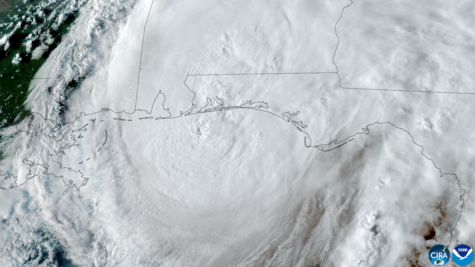
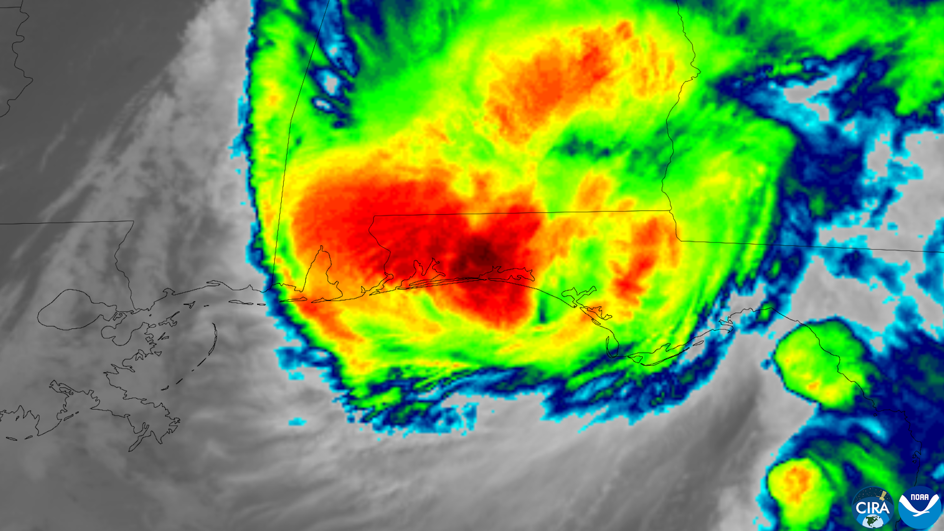
Isaias developed in the western Gulf despite atmospheric conditions that had blocked or shredded many systems earlier in the season. Warm water and a brief pocket of favorable upper-level flow allowed rapid strengthening close to land. Forecast models then faced a nail-biting six-hour window as the hurricane approached Category 3 intensity.
Increasing wind shear disrupted the storm before landfall and knocked it from Category 3 strength to Category 2. That change likely spared the Panhandle a much worse wind and surge disaster; destructive potential rises sharply with wind speed. Fox Weather reported storm surge above five feet, serious but below the outcome feared if the core had retained its earlier organization.
The Panhandle's institutional memory is built around Ivan in 2004 and Michael in 2018. Ivan exposed the region's vulnerability to surge, bridges and prolonged outages. Michael showed what rapid intensification can do when a major hurricane arrives with little margin for evacuation. Isaias did not reproduce either catastrophe, but it tested whether lessons about shelters, hardened utilities and fast-moving forecasts had become durable practice.
Forecasting improved, but warnings still face a human deadline
Fox Weather reported that a Google DeepMind model produced the best track forecast among the guidance examined. A better track is valuable because it concentrates evacuations and prepositions crews. Yet forecast accuracy cannot resolve every late change in intensity, and critics will ask whether the rapid strengthening left enough time for coastal households to act. DeSantis expanded Florida's state of emergency to 27 North Florida counties on October 8, while local orders and warnings varied with surge zones and expected conditions.
The fairest test is not whether every resident evacuated but whether officials communicated the shrinking window, opened suitable shelters and explained the distinct risks of wind, surge, falling trees and generator use. The last of those often receives less attention before landfall even though it becomes deadly after the lights go out.
Who bears the cost — and who powers the recovery
Families, renters and small businesses lose first
Families in homes beneath mature trees bore the storm's most irreversible cost. Renters and lower-income households are often next: they have less control over roof repairs, fewer savings for hotels and generators, and less ability to replace refrigerated food. Pensacola's restaurants, shops and tourism businesses now face a weekend of closures followed by uncertain water, power and insurance timelines.
Lineworkers and relief groups become the recovery machinery
Lineworkers, public-works crews and utility dispatchers are the hinge between emergency response and normal life. Convoy of Hope mobilized assistance in Pace, Gulf Breeze offered free water to residents in the 32561 ZIP code with identification, and Destiny Worship Center planned a mass feeding for Sunday, October 11. Those networks do not erase the losses, but they convert supplies, local knowledge and volunteer labor into immediate capacity while government assessments proceed.
The infrastructure question will remain after service returns. A Category 2 storm that left close to a million customer accounts dark will sharpen scrutiny of tree trimming, pole replacement, buried lines and mutual-aid staffing. Utilities can reasonably argue that 117 mph gusts will overwhelm even well-maintained systems. Residents can reasonably ask why failures were so widespread and whether vegetation management and grid hardening kept pace with coastal growth.
What happens next: inland flooding, tornadoes and weeks of repairs
By 11 a.m. Eastern Saturday, the post-tropical center was about 50 miles south of Birmingham and moving north toward the Tennessee Valley before an expected northeast turn. The tornado risk covered southern Alabama, the Florida Panhandle, southwest Georgia and southern South Carolina on Saturday, then shifted Sunday toward eastern North Carolina, eastern South Carolina and southeastern Virginia.
Forecasters expected a broad 3 to 5 inches of rain, with 6 to 10 inches possible in far western North Carolina and upstate South Carolina. That moves the hazard from coastal wind to inland flash flooding and spin-up tornadoes, which can arrive far from the landfall point. Residents along the inland track should not treat the post-tropical designation as an all-clear.
The O'Reilly Auto Parts Series race at Charlotte was postponed to Sunday, while the Cup Series race remained scheduled for 3 p.m. Eastern despite an 80% rain chance. In Pensacola, the Bay Center shelter closed, while Wedgewood remained open for residents with special needs. Recovery in the hardest-hit Panhandle counties is likely to take weeks rather than days.
The next official signals to watch are county damage assessments, any federal disaster declaration and the scope of state reimbursement for debris removal and public infrastructure. Forecasters will also monitor the Caribbean next week for new development. For the Gulf Coast, however, the immediate work is close to home: account for residents, keep generators outdoors, clear roads, restore water pressure and reconnect neighborhoods one circuit at a time.