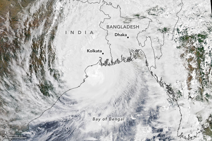
Bay of Bengal deep depression landfall is forecast near Kalingapatnam on Wednesday night, September 23, after the India Meteorological Department placed the storm center at 18.0°N, 84.7°E at 5:30 a.m. IST. IMD said the system was moving west and expected to cross the north Andhra Pradesh–south Odisha coast between Visakhapatnam and Gopalpur, close to Kalingapatnam, with sustained winds of 55–65 kmph and gusts to 75 kmph.
Red warnings cover Coastal Andhra Pradesh and Yanam, Telangana, Odisha and Chhattisgarh. Schools were ordered closed in Srikakulam, Vizianagaram, Parvathipuram Manyam, Visakhapatnam, Alluri Sitharama Raju and Anakapalle, as well as affected Odisha districts. Fishermen were told to remain ashore. The immediate coastal strike is only the first phase: heavy to extremely heavy rain is forecast to follow the weakening system inland through September 24 and 25.
The accuracy line matters. IMD had classified the system as a deep depression, not a cyclonic storm, at the reporting cutoff. “Arnab,” Bangladesh’s proposed name meaning “ocean,” would apply only if the circulation intensifies to cyclonic-storm strength. Reports discussing a possible cyclone Arnab landfall are therefore describing a conditional scenario, not the storm’s established name or classification.
The storm’s position and forecast
At 5:30 a.m. IST, the center was about 70 km east-southeast of Kalingapatnam, 150 km south of Gopalpur, 150 km east-northeast of Visakhapatnam and 230 km south-southwest of Puri. The reported westward motion—varying between about 7 and 12 kmph across updates—placed the circulation on a short approach toward the coast.
The forecast corridor is the stretch between Visakhapatnam and Gopalpur, with the crossing point expected close to Kalingapatnam by Wednesday night. That makes the Visakhapatnam Gopalpur coast storm threat a two-state event: wind and very heavy rain can extend far from the center even if the eventual crossing point lands on one side of the Andhra–Odisha boundary.
Ports in Odisha and at Kalingapatnam, Bheemunipatnam, Visakhapatnam, Gangavaram and Kakinada were displaying local cautionary signal III. Distant cautionary signals were in place along Tamil Nadu and Puducherry. Those signals are operational warnings for mariners and ports; they do not change the IMD classification of the weather system.
Why this matters
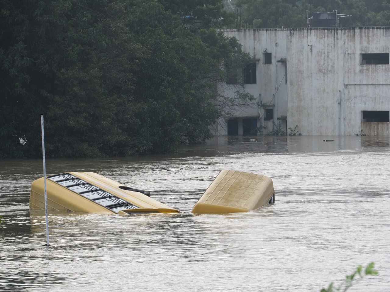
Storm categories describe wind structure. They do not set a ceiling on rainfall or flood mortality. A deep depression can still kill through flash flooding, river rises, collapsing walls, fallen trees, electrocution, road washouts and dangerous seas. The most damaging hours may occur after the center crosses land, when people assume the emergency is ending but saturated catchments are still receiving rain.
IMD’s phrase “extremely heavy rainfall” means at least 20 cm in 24 hours. In dense cities, that amount can overwhelm drains, underpasses and low-lying roads; in rural districts it can cut villages off and wash out culverts. The Odisha heavy rain warning therefore carries a wider risk than the coast alone, while the Telangana Chhattisgarh rain alert points to the system’s inland path.
There is also a narrow benefit. Broad, sustained rain can recharge reservoirs, tanks and groundwater after uneven monsoon distribution. But recharge becomes a benefit only where storage has capacity and releases are managed. If reservoirs are already high, rapid inflows can force releases that worsen downstream flooding. The same rainfall can be useful at basin scale and dangerous at village scale.
How we got here
The northern Bay of Bengal is warm and moisture-rich late in the monsoon, and September systems often track toward India’s east coast before the peak post-monsoon cyclone window. October and November are normally the prime Bay of Bengal cyclone months, so the Bay of Bengal cyclone season 2026 is entering its most closely watched period even though the present system remained below cyclonic-storm status at the cutoff.
A useful geographic parallel is Cyclone Gulab in September 2021. Gulab crossed a similar north Andhra Pradesh–south Odisha corridor near Kalingapatnam after moving west from the Bay. The comparison is about track and exposure, not identical intensity or impacts: landfall outcomes depend on storm structure, rainfall distribution, tides, soil saturation and the speed of movement.
The 1999 Odisha super cyclone remains the region’s benchmark for catastrophic coastal loss of life and destruction. Since then, better forecasting, cyclone shelters, evacuation planning and last-mile alerts have sharply improved preparedness. Later death-toll comparisons must still be handled cautiously: storms differ in track and intensity, populations and buildings change, and reported totals are not always measured the same way.
Seasonal risk should not be conflated with an unverified “super El Niño year” label. The relevant operational facts are the current IMD track, wind and rainfall forecasts, not a dramatic climate tag unsupported by the reporting sources used here. For a separate look at how governments prepare for climate-linked extremes, see our analysis of California’s El Niño emergency planning.
Who it hits hardest
Fishing communities face the clearest immediate danger. A ban on going to sea protects crews only if boats are secured, warning messages reach small harbors and families have safe shelter. Fishing income can also be lost for several days after landfall while seas remain rough and ports inspect channels and equipment.
Farmers face harvest-season losses that wind categories do not capture. Paddy close to harvest can lodge or flatten under gusts to 75 kmph, while vegetables may be damaged by waterlogging, salt spray and prolonged standing water. Small farmers can lose a season’s income even when a storm produces limited structural damage in a nearby city.
Residents in light housing are vulnerable to roofing failures and wall collapse. Thatched roofs and mud homes can be damaged by repeated gusts and soaking rain. With Andhra Pradesh schools closed across seven named districts, classrooms can remain available for emergency use and road exposure falls, but closures do not protect households unless local shelter and transport plans work.
Ports, logistics and travelers face compounding disruption. Visakhapatnam and Paradip are major industrial and shipping nodes; precautionary vessel movements, cargo pauses or road restrictions can ripple into supply chains. Rail and road passengers face flooded tracks, reduced visibility, fallen trees and sudden diversions long after the wind center passes. Official district notices—not social-media reposts or search phrases such as “NDRF teams Odisha storm”—should guide evacuation and travel decisions.
The numbers
18.0°N, 84.7°E: the reported center at 5:30 a.m. IST. A storm’s center is not its impact boundary; hazardous rainbands can extend hundreds of kilometers away.
70 km: the distance east-southeast of Kalingapatnam at that bulletin time. The center was also about 150 km from both Gopalpur and Visakhapatnam and 230 km from Puri.
7–12 kmph: the reported westward movement range. Slower motion can prolong rain over one basin; faster motion can carry the rain threat inland more quickly.
55–65 kmph, gusting to 75 kmph: the forecast wind range near crossing. Gusts at that level can bring down weak branches, damage temporary structures and flatten crops, especially where soil is saturated.
31–50, 51–61 and 63–88 kmph: the IMD wind bands for a depression, deep depression and cyclonic storm respectively. The depression vs cyclone IMD classification question can look confusing because a reported wind range may overlap a threshold. The official IMD classification governs: the agency evaluates the analyzed system as a whole, not a single gust or isolated end of a forecast range.
20+ cm in 24 hours: the threshold for “extremely heavy rainfall.” That is enough to create serious urban-waterlogging and flash-flood danger even without cyclonic-storm designation.
What happens next
The first checkpoint is the pre-landfall IMD bulletin: whether the center maintains deep-depression strength, weakens or crosses the 63 kmph cyclonic-storm threshold. Until IMD formally upgrades it, headlines should continue to say deep depression. The second checkpoint is the actual crossing point and timing, because a shift of several dozen kilometers changes which rivers, ports and districts receive the most persistent rainbands.
After landfall, attention moves west. The circulation is forecast to weaken over land, but its moisture will move across Telangana and Chhattisgarh. Alerts remain relevant through September 24, with pockets of flood risk potentially continuing into September 25 as runoff reaches rivers and reservoirs. Travelers should check rail, road and district advisories before departure rather than infer safety from a calmer coast.
Authorities must balance early action against false-alarm fatigue. Repeated closures and evacuations impose real costs, particularly on daily-wage workers and farmers. But waiting for certainty shortens evacuation time and can turn a manageable flood into a rescue operation. The policy answer is not fewer warnings; it is more precise local messaging, clear expiry times and transparent explanations when forecasts change.
The broader lesson echoes other storms: preparation is measured by whether warnings reach the people most exposed, not by the label attached to the circulation. Our coverage of Typhoon Dujuan evacuations in Japan examines the same problem from a different coastline—how transport, shelters and public trust determine the outcome once a forecast becomes an operational decision.
Sources
- India Meteorological Department bulletins and warnings via @Indiametdept, including the 5:30 a.m. IST position and classification used in this report.
- The Hindu BusinessLine: heavy rain forecast for Odisha, coastal Andhra Pradesh, Chhattisgarh and Telangana.
- LatestLY: deep depression forecast and conditional Cyclone Arnab framing.
- Business News This Week: landfall, wind and rainfall forecast.
- Inshorts: warning summary and conditional naming report.
Reporting cutoff: September 23, 2026 at 5:30 a.m. IST. This is a fixed snapshot, not a live warning service. Track, rainfall and closure information can change; follow IMD and local authorities for the latest instructions. Analysis of crop exposure, infrastructure effects, recharge benefits and false-alarm fatigue is Signal Post News synthesis.