California Gov. Gavin Newsom proclaimed a statewide state of emergency on Monday, September 21, mobilizing agencies months before the core of the 2026–27 rainy season as forecasters track what could become the strongest El Niño in the modern record. The declaration follows a September 10 NOAA outlook that put the chance of a very strong El Niño this fall and winter above 90%.
NOAA’s experimental Relative Oceanic Niño Index probabilities go further: the agency assigns a 75% chance that the event reaches “historic” strength during October–December, defined in that product as a three-month RONI value of at least +2.5 degrees Celsius and above every comparable value in the record beginning in 1950. “Super El Niño” is a popular shorthand, not an official scientific category, and neither probability is a prediction of a specific California storm.
That distinction is the heart of the story. The governor’s announcement says plainly that El Niño does not guarantee a wet winter or a particular storm. Yet the cost of waiting until a destructive atmospheric river appears in the forecast can be measured in blocked culverts, unstaffed shelters, unavailable pumps and evacuation routes repaired too late. The order is therefore more than an emergency label. It signals how climate-amplified weather is forcing government to plan against high-consequence risk before certainty arrives.
What the emergency order changes
The signed proclamation gives state agencies a wider operational lane for preparation. It directs them to protect vulnerable communities, assess and prepare infrastructure, stage supplies and equipment, and identify regulatory or permitting barriers that could slow urgent work. Caltrans is told to ready personnel and equipment for flooding, landslides and road damage. The California National Guard is placed in readiness for flood response, search and rescue, engineering and logistics.
Newsom framed the move as anticipatory rather than reactive. “We are preparing for this El Niño early because every Californian deserves to be safe in their home, connected to their community, and protected when severe weather comes,” he said. California Office of Emergency Services Director Caroline Thomas Jacobs made the same point more bluntly: “We are not waiting for this season’s storms to be on our doorstep.”
The declaration can shorten administrative timelines and improve coordination, but it does not itself build a flood wall, clear a channel or guarantee local execution. State departments, counties, cities, utilities and private contractors still have to turn authority into completed work. Nor did the proclamation attach a comprehensive new spending total. Any claim that the declaration has a fixed price tag—or that it forecasts a fixed loss—would go beyond the public documents.
The statewide action also sits beside same-day recovery proclamations covering Glenn, Humboldt, Kern, Mendocino and Santa Barbara counties, as well as a sewage spill in Lake County. Those actions concern existing damage and cleanup; the El Niño proclamation concerns prospective statewide preparedness. Their coincidence shows the administrative reality California faces: recovering from prior disasters while preparing for the next season.
Why this matters
Disaster policy usually becomes visible after impact: helicopters over a flooded neighborhood, emergency shelters, road closures and federal aid requests. This order moves the consequential decisions earlier, when the work is less dramatic but often more effective. Clearing drainage systems, reinforcing slopes, checking pumps, mapping medically vulnerable residents and pre-positioning rescue equipment can reduce losses across many possible storm tracks.
The planning horizon is changing because baseline conditions are changing. Warmer air can hold more water vapor, warmer seas can intensify rain-producing systems, higher sea levels allow waves and tides to reach farther inland, and severe wildfire seasons leave burn scars prone to debris flows. El Niño does not create each vulnerability, but it can align with them. A state preparing for the interaction is not claiming to know the winter’s exact outcome; it is recognizing that the downside has grown too large to manage at the last minute.
That makes the declaration a low-regret decision. If the winter is milder than feared, cleaned channels, inspected levees and practiced response plans still have value. If storms arrive in sequence, the same work can determine whether an emergency remains local or cascades through transport, housing, energy and public health systems.
What El Niño is—and what “super” does not mean
El Niño is the warm phase of the El Niño–Southern Oscillation, a recurring shift in tropical Pacific Ocean temperatures, winds and atmospheric circulation. When unusually warm water spreads across the central and eastern equatorial Pacific, it can rearrange the jet stream and change weather patterns around the world.
For California, a strong El Niño raises the odds of a wetter winter, especially in the south, but the relationship is probabilistic rather than mechanical. The position of the jet stream, atmospheric-river tracks, the timing of individual storms and other ocean-atmosphere patterns all matter. One county can flood while another remains below normal. A seasonal ocean index cannot tell a resident whether a particular creek will rise on a particular night.
“Super El Niño” has no single official threshold. Forecasters and journalists generally use it for an exceptionally strong event, often one with sea-surface temperature anomalies near or above 2 degrees Celsius by a conventional index. NOAA’s 2026 product uses the newer RONI, which adjusts for the warming tropical background and defines its “historic” scenario at +2.5 degrees Celsius or higher. Those definitions describe the Pacific signal. They do not automatically translate into a corresponding rank for California rainfall, damage or snow.
1997–98 and 2015–16: two warnings, two different winters
The 1997–98 El Niño is California’s clearest modern disaster comparison. Contemporary and retrospective estimates differ by what they count, placing statewide damage at roughly $550 million to $883 million. Seventeen people died, and federal disaster declarations ultimately covered roughly three dozen counties. Flooding, landslides, coastal damage and transportation disruption demonstrated how a powerful ocean pattern can combine with local exposure.
But the 2015–16 event is the essential caution against deterministic forecasts. It reached a record traditional Oceanic Niño Index value of about +2.64 degrees Celsius, yet Southern California received far less rain than many comparisons with 1982–83 and 1997–98 had led the public to expect. The storm track did not follow the simplest storyline.
That winter was not harmless. A U.S. Geological Survey study found exceptional wave energy and widespread erosion along the West Coast. The lesson is not that forecasters were wrong to take the event seriously. It is that El Niño strength and California rainfall are related but not interchangeable, while coastal impacts can be severe even when the rainfall map disappoints expectations.
A stronger climate signal meets a higher coast
New research suggests the physical phenomenon itself is changing. An August 27, 2026 study in Science, summarized in CNN’s climate reporting and Phys.org, concluded that El Niño events are about 36% stronger than before the industrial era and that the strengthening accelerated over the past four decades. As with any single study, the result should be tested and refined, but it adds evidence that historical averages may understate future extremes.
California’s coast also faces a timing problem. Coastal scientist Patrick Barnard has noted that the emerging event overlaps the peak of an 18-year high-tide cycle. El Niño winters can deliver roughly 30% more wave energy than average, while past super El Niños have produced increases near 50%. Add elevated seasonal tides and long-term sea-level rise, and waves need not be record-setting to reach roads, homes and utilities more often.
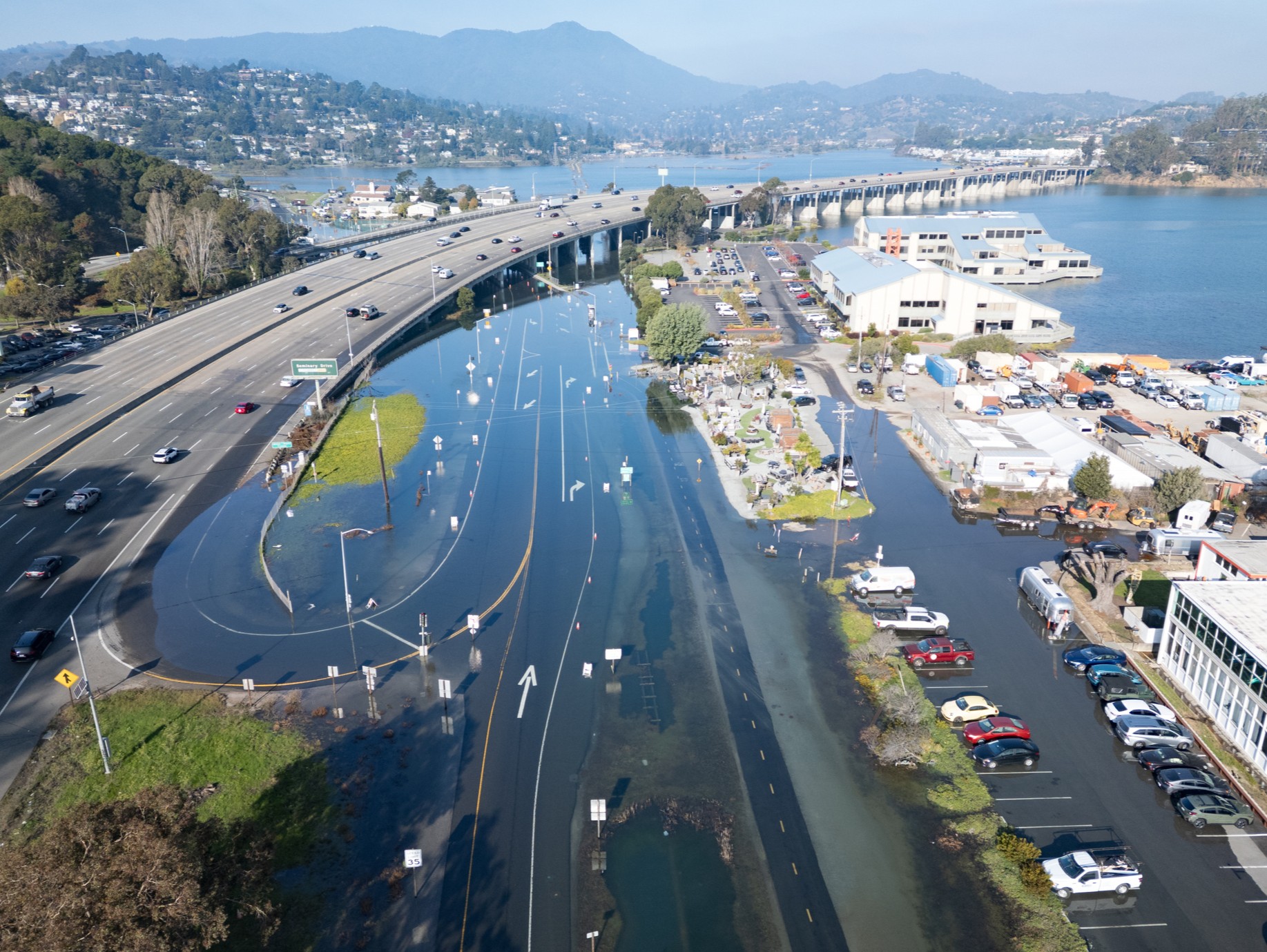
The photograph above illustrates that compound exposure. It shows King Tide flooding near highways in Mill Valley during December 2025—not storm damage from this event. King Tides are predictable astronomical highs. Their value as a warning is that they reveal where ordinary drainage and transportation networks already meet the water before storm surge, waves or heavy runoff are added.
Winners, losers and uneven risk
A wet winter can bring real gains. Reservoirs may refill, aquifers may receive more recharge and snowpack can improve water supply if precipitation falls and remains as mountain snow. Ski areas, winter tourism and some water-dependent ecosystems could benefit. Farmers with secure drainage and storage may gain from improved water availability after dry periods.
Those benefits are conditional. Warm storms can fall as rain at elevations that would normally store water as snow, rapidly sending runoff downstream. Reservoir operators may have to release water for flood control just as they try to capture supply. Recharge works only where water can be routed onto suitable ground. A large total can therefore coexist with missed opportunities and destructive peaks.
The clearest losers are people and systems in low-lying, coastal, hillside and burn-scar areas. Homeowners face physical damage and insurance gaps. Renters can lose housing, belongings and wages even when the building owner carries coverage. Roads, rail corridors, wastewater plants, power lines and communications systems can fail at points that disrupt much larger regions. Agriculture faces flooded fields, livestock risk, erosion and delayed planting. Insurers and public budgets absorb claims and repair costs, while households without coverage may rely on limited aid or debt.
The burden will not be equal. Communities with fewer savings, limited transportation, language barriers, disability-access needs or histories of underinvestment have less room to evacuate, replace belongings or wait for repairs. That is why the proclamation’s direction to protect vulnerable communities matters—but the result must be judged by where pumps, warnings, shelters and money actually go.
Prudence without prophecy
There is a legitimate tension in declaring an emergency before a disaster. Emergency powers can accelerate work and focus attention; they can also become routine, bypass normal review or create expectations that every alarming forecast will become a catastrophe. Skepticism should be directed at execution, evidence and proportionality—not supported with invented accusations.
The most credible case for the order is practical. A declaration cannot make the forecast more certain, but it can reduce the consequences of being caught unprepared. Many preparatory actions are useful under several winter scenarios and cheaper than emergency repairs. The most credible caution is equally practical: NOAA’s odds refer to ocean conditions, not a guaranteed California deluge, and 2015–16 showed that a very strong El Niño can produce an uneven and surprising state rainfall pattern.
The right standard is therefore not whether every county experiences a disaster. It is whether agencies use the lead time for specific, transparent and reversible work; whether communities at highest risk see concrete protection; and whether expedited authority remains tied to genuine preparedness needs.
What the winter could look like
In a high-impact scenario, repeated atmospheric rivers could saturate soil and then push rivers and urban drainage systems past capacity. Heavy rain over recent burn scars could trigger debris flows with little warning. Coastal storms arriving near King Tides could drive erosion, wave overtopping and flooding. Warmer systems could raise snow levels, while colder intervals could produce deep Sierra snow followed by rain-on-snow runoff. Road closures, power outages and rail disruption could compound one another.
A moderate scenario could still produce damaging episodes separated by long quiet periods: one coastal erosion event, one burn-scar evacuation, several localized floods and beneficial mountain snow elsewhere. A low-impact scenario would see the strongest Pacific signal fail to align with the storm tracks that deliver exceptional rain to California. None can be selected confidently in September.
Forecast confidence should improve as the season approaches and short-range models identify individual systems. Residents should treat watches and warnings from the National Weather Service and instructions from local emergency managers as actionable information. The statewide declaration is the readiness frame; local forecasts will determine when and where action is necessary.
What residents can do now
Preparation begins with location-specific risk. Residents can check whether a home lies in a mapped flood zone, below a steep or recently burned slope, or along an evacuation route with limited alternatives. Clear gutters and drains where it is safe and lawful, document belongings, store medications and essential records, plan for power loss, and know how to receive county alerts. People who may need transportation or medical support should identify assistance before a warning is issued.
Insurance deserves special attention. Reporting cited by Claims Pages put flood-insurance penetration at only about 1.4% of California homes. Standard homeowners policies and California FAIR Plan fire coverage generally do not cover flooding; separate flood coverage is usually required. Policies can have waiting periods, coverage limits and exclusions, so reviewing terms after a storm is named may be too late. Renters should ask specifically about contents coverage and understand that a landlord’s policy generally protects the structure, not a tenant’s belongings.
No insurance decision should rest on a statewide headline alone. Property-specific exposure, deductibles, replacement costs and federal or private policy terms matter. The useful question is not “Will El Niño hit California?” but “What water-related losses could happen at this address, and what would pay for them?”
What happens next
State agencies now have to convert the proclamation into a public inventory of preparation: which culverts and channels are being cleared, which levees or slopes need urgent work, where supplies are staged, how National Guard readiness is defined, and whether counties have identified residents who need evacuation help. Permitting acceleration should produce dated projects and accountable decisions, not merely faster paperwork.
Forecasters will watch the event’s strength and duration, the developing jet stream and the probabilities of atmospheric-river landfalls. Water managers will watch reservoir space, snow levels and soil saturation. Coastal communities will watch wave forecasts and King Tide calendars. Insurance officials will watch uptake, claims capacity and whether policyholders understand the flood exclusion before damage occurs.
Newsom’s declaration cannot settle the meteorology. It can set the terms of preparedness. If California uses the autumn to reduce known vulnerabilities, the policy may succeed without producing a dramatic rescue image. That is the point of acting months ahead: the best evidence of readiness is often damage that never happens.
Sources and reporting notes
- Office of Governor Gavin Newsom, September 21, 2026: statewide emergency announcement, quotations and preparedness directives
- Signed statewide El Niño state-of-emergency proclamation
- NOAA Climate Prediction Center, September 10, 2026: El Niño advisory and seasonal outlook
- NOAA Relative Oceanic Niño Index probabilities: definitions and historic-strength probability
- CNN, September 22, 2026: proclamation details, historical comparison and forecast context
- KTLA, September 21, 2026: California preparedness actions and local context
- U.S. Geological Survey: wave energy and West Coast erosion during the 2015–16 El Niño
- CNN, August 27, 2026: reporting on the Science study of El Niño strengthening in a warming climate
- California Coastal Commission, California King Tides Project gallery: contextual lead photograph and public-use credit guidance
Reporting cutoff: September 22, 2026. Forecast probabilities describe the likelihood and strength of Pacific ocean-atmosphere conditions, not a guaranteed statewide rainfall or damage outcome. Historical loss estimates vary by methodology. Forward scenarios and winners-and-losers analysis are Signal Post News’s synthesis of the cited official documents, reporting and research.