Hurricane Nolo Hawaii
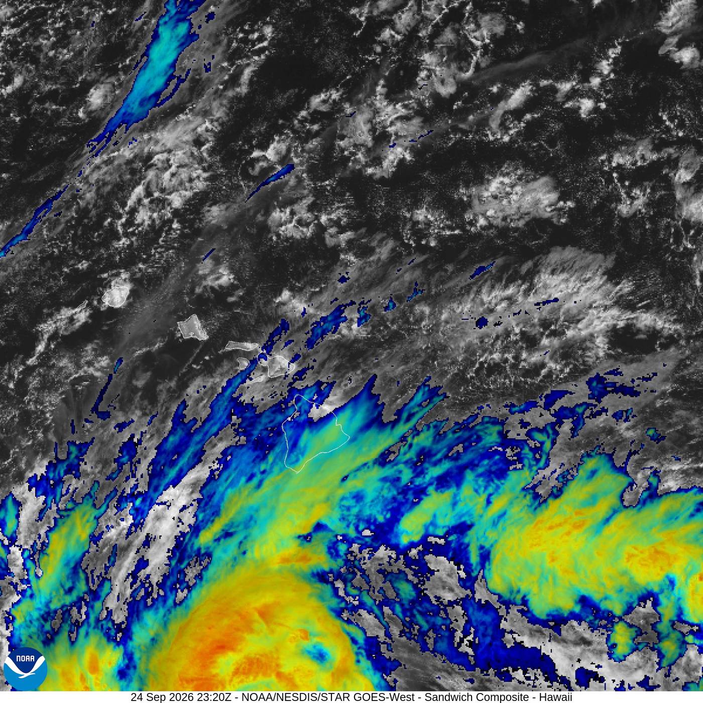
HONOLULU — The Hurricane Nolo Hawaii threat sharpened Thursday as a strengthening tropical storm developed a ragged eye roughly 285 miles south of the Big Island, carrying sustained winds near 70 mph and creeping north at about 2 mph. Forecasters expected Nolo to become a hurricane Thursday night and approach late Friday into Saturday as a high-end Category 2 or Category 3 system.
A hurricane watch was in effect for Hawaiʻi County, alongside a tropical storm warning for the island of Hawaiʻi. Maui, Lānaʻi, Molokaʻi and Kahoʻolawe were under tropical storm watches. The National Hurricane Center warned that “life-threatening, catastrophic flooding and mudslides are possible, especially in areas of steep terrain across the Big Island and Maui.”
The danger is not confined to the line drawn through the center of a forecast cone. Nolo’s slow movement gives its rainbands time to repeatedly cross the same slopes, while a modest shift toward the islands would expose more communities to damaging winds. The Big Island could receive 10 to 15 inches of rain, with isolated totals near 35 inches; Maui could see 5 to 10 inches, locally 20; and other islands could receive 1 to 3 inches.
Why this matters
Hawaiʻi’s steep volcanic terrain turns tropical rainfall into an unusually fast-moving public-safety problem. Water falling on saturated uplands can funnel into streams, cut roads, destabilize slopes and isolate neighborhoods well before the storm’s strongest winds arrive. A forecast of 35 inches is therefore not simply an unusually large rain total. It is a warning about access: whether ambulances can move, whether families can reach shelters and whether repair crews can safely restore power.
Hurricane-force winds above 75 mph were possible along the Big Island’s south side, with stronger gusts at elevation and in areas where ridges accelerate the flow. That creates a compound hazard. Floodwater can block the route around a fallen tree or damaged utility pole, while an outage can disable pumps, communications and refrigeration just as people are told to remain indoors.
Governor Josh Green activated emergency preparations. Shelters were opening, and Big Island public schools and some state offices were closing. The Hawaiʻi Emergency Management Agency urged residents and visitors to take the threat “very seriously,” review family plans, prepare for outages and consider safer shelter where flooding, surf or road access could become dangerous. An Air Force Reserve Hurricane Hunter mission was scheduled to investigate Nolo on September 24, giving forecasters direct measurements from inside the storm.
The rainfall number is more alarming than the category
The temptation is to treat Nolo’s eventual category as the verdict. That would be a mistake. The Saffir-Simpson scale describes sustained wind, not rainfall, landslide potential or the ability of a community to absorb several storms in one season. Nolo’s projected isolated maximum of 35 inches is close to the 40-plus inches dumped by Lala in August 2026, and it would arrive on ground that has had limited time to recover from Lala, Lowell and earlier Kona Low damage.
Hurricane Lane showed the scale of what a near miss can do. In 2018, Lane did not make a direct hurricane landfall on the Big Island, yet it produced more than 50 inches of rain in parts of Hawaiʻi. The lesson is not that Nolo will repeat Lane; the forecast totals are lower and the exact track is unsettled. The lesson is that the most destructive outcome can come from water delivered over time, even when the center stays offshore.
Iselle in 2014 remains the most relevant direct Big Island comparison: it came ashore as a tropical storm after weakening from hurricane strength, damaging homes, crops and utilities. Hurricane Iniki’s devastating 1992 strike on Kauaʻi is the deeper historical warning about what an intense cyclone can do when the track aligns with an island. Neither storm is a template. They are reminders that Hawaiʻi’s history contains both damaging landfalls and costly near misses.
Landfall and near-miss scenarios
In the more severe scenario, Nolo’s center tracks close enough to the southern Big Island for the inner core to bring sustained hurricane-force winds to exposed coastal districts and higher terrain. That would add structural damage, prolonged outages, debris-blocked roads and agricultural losses to the flood emergency. A track over or very near land could also generate dangerous coastal surge and surf, although local effects would vary sharply with shoreline shape and the timing of the closest approach.
In the near-miss scenario favored by many model members Thursday, the center turns west south of the island as a ridge builds. That would reduce the area exposed to Nolo’s strongest winds but would not eliminate the flood threat. Outer rainbands can extend far from the eye, and orographic lift can wring out exceptional rain where moist air is forced up the volcanic slopes.
The distinction could turn on a relatively small track change. The National Hurricane Center said ensemble guidance still included tracks over the Big Island even though most members lay to the south. It also warned that a closer track would substantially increase damaging-wind risk, particularly on ridges, at higher elevations and in downwind areas. Forecast confidence should be understood in layers: confidence is high that heavy rain will affect parts of the state; confidence is lower about exactly where the inner core will pass.
Who bears the losses — and where there may be limited benefit
Residents in mapped flood zones and neighborhoods with a single access road face the most immediate risk. Visitors may be less familiar with evacuation routes, stream crossings or the speed at which conditions change. Tourism businesses face cancellations and closures at the start of a weekend, while farms can lose crops, fencing, livestock access and days of work even without a direct hit. The power grid is vulnerable not only to wind but also to landslides and washed-out access routes that slow repairs.
There is one real but narrow benefit: sustained rain can replenish reservoirs, catchments and groundwater after dry periods. That matters in an island state with limited freshwater storage. But rain becomes useful water only when it falls slowly enough to be captured without overwhelming drainage systems or carrying soil, debris and contaminants into waterways. At Nolo’s projected intensity, the balance tilts toward loss long before every reservoir is full.
The economic damage will also be uneven. A hotel able to close for a day and reopen may absorb the interruption. A small farm losing a harvest, a family whose home sits below a saturated slope or a community waiting days for a washed-out road does not have the same cushion. Recovery figures should therefore be read beyond the statewide total: duration and concentration matter as much as the headline cost.
A readiness test for building codes and evacuation infrastructure
Critics of Hawaiʻi’s disaster planning have a fair question: have building standards, shelter capacity and evacuation routes kept pace with a season in which tropical systems repeatedly threaten the islands? Modern wind codes can reduce structural failure, but code quality does not retrofit every older home or protect a road from slope collapse. A shelter is only useful if people can reach it before streams rise, and an emergency alert is only useful if it reaches visitors as well as residents.
The right test is not whether preparations appear extensive before impact. It is whether backup power works, shelters can accommodate people with medical and mobility needs, public messages are consistent across counties and crews have enough equipment positioned on both sides of likely road closures. Those are operational questions that become visible only when the weather arrives.
A hyperactive Pacific raises the stakes
Nolo is approaching during a strengthening El Niño and over unusually warm Pacific water, conditions that can favor more tropical activity in the central and eastern Pacific. Hawaiʻi has faced at least five tropical threats in 2026. Lala brought extraordinary rain in August; Lowell generated warnings earlier in September; and successive winter Kona Lows left some roads, homes and utilities more exposed than a clean seasonal baseline would suggest.
Farther east, Category 5 Hurricane Polo was threatening Mexico’s Pacific coast. The storms are separate systems, but their simultaneous strength illustrates how a favorable basin-wide environment can stretch forecasting, aviation reconnaissance and public attention. Our analysis of the 2026 super El Niño’s projected health toll explains why the same ocean pattern can produce sharply different hazards across regions.
The comparison with Typhoon Dujuan’s mass evacuations around Tokyo is also useful. Japan’s transport network and Hawaiʻi’s island geography differ, but both show that forecast accuracy is only half the problem. The other half is converting a warning into movement before roads, airports or ports become unsafe.
What to watch during the next 48 hours
- Reconnaissance data: Hurricane Hunter measurements of the pressure, wind field and inner-core structure could confirm faster intensification or show that Nolo remains less organized than satellite estimates suggest.
- The turn: Watch when Nolo accelerates north-northeast and how sharply it turns west. A delay of several hours could place the core materially closer to the Big Island.
- Rainband placement: Repeated bands over windward and southeastern districts would raise flash-flood and mudslide risk even if the center stays offshore.
- Warning changes: A hurricane warning would mean hurricane conditions are expected, rather than merely possible, generally within 36 hours.
- Local closures: County notices about shelters, road access, schools, parks and utilities will be more actionable than national summaries for people on the islands.
Recovery could range from days to months
If Nolo makes a clean turn and the heaviest bands remain limited, airports, schools and businesses could begin reopening within days after safety inspections. Power restoration would depend on the location of damaged lines and whether roads remain passable. Even in that outcome, saturated slopes and swollen streams can stay dangerous after the center has moved away.
A closer pass or landfall would create a longer sequence. Initial rescue and debris clearance could take days; utility and road repairs could take weeks; heavily damaged homes, farms and water systems could require months. Tourism may rebound faster than residential recovery, a familiar pattern that can make an island appear normal to visitors while affected communities are still navigating insurance, contractors and temporary housing.
Nolo’s forecast will change as new aircraft and satellite data arrive. That uncertainty is not a reason to wait. It is the reason watches are issued before the last track is known. The prudent judgment Thursday is neither to declare a catastrophe inevitable nor to treat a near miss as assured: prepare for the dangerous edge of the forecast while continuing to watch the evidence.
Sources and further reading
- National Hurricane Center: Tropical Storm Nolo forecast discussion, September 24, 2026
- National Hurricane Center: Tropical Storm Nolo advisory graphics
- Hawaiʻi Emergency Management Agency: Tropical Storm Nolo updates
- USA Today: Nolo live updates and Hawaiʻi rainfall forecast
- CNN: El Niño, Hurricane Polo and Nolo’s threat to Hawaiʻi
- Fox Weather: Nolo and the risk of a rare direct Hawaiʻi landfall
- Insurance Journal / Associated Press: Hurricane watch posted for the Big Island
- NOAA / NESDIS / STAR: Hawaiʻi satellite imagery
Reporting basis: Fixed September 24, 2026 snapshot. Forecast positions, wind speeds and rainfall amounts will change as Nolo evolves; readers in Hawaiʻi should follow official local alerts.