Hurricane Polo makes landfall
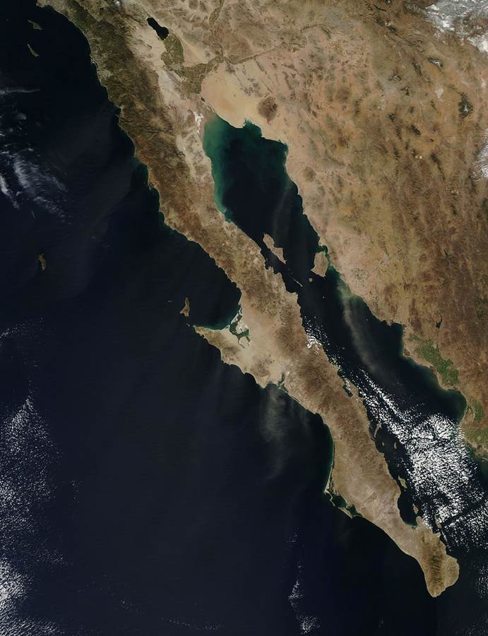
BAJA CALIFORNIA SUR, Mexico — Hurricane Polo makes landfall the defining fact of Tuesday morning after the storm crossed Mexico’s Pacific coast just south of Las Barrancas with maximum sustained winds of 110 mph (175 kph), according to the U.S. National Hurricane Center in Miami. The center put Polo’s minimum pressure at 965 hPa and said it was moving northeast at 13 mph (20 kph), a course expected to carry the circulation across the peninsula and toward southern Sonora.
The landfall point was about 80 miles (130 kilometers) north of Cabo San Lázaro and about 70 miles (115 kilometers) south of Mulegé. That placed the storm’s core near sparsely populated coastline, but not beyond reach of fishing communities, roads and power systems. In Puerto San Carlos, a port of roughly 6,000 people, seawater breached sand barriers and ran into streets as palms bent in the wind. Electricity was cut and residents were ordered to shelter.
Juan Manuel Sarabia, a 53-year-old whale-watching and fishing guide, reinforced his home with wooden beams. “It’s coming with full force,” he told AFP. Mexico’s meteorological service chief, Fabián Vázquez, warned that storm surge and heavy rain could cause “very severe” damage. Authorities opened 169 shelters across Baja California Sur before the core arrived.
Hurricane Polo Category 2 at landfall: what the numbers mean
The National Hurricane Center and Associated Press figures make Polo a Category 2 hurricane at landfall: 110 mph winds, one mile per hour below the 111 mph threshold for Category 3 on the Saffir-Simpson scale. Polo had reached 115 mph on Monday, making it a Category 3 hurricane over water before modest weakening. That narrow numerical gap helps explain why some early reports described a Category 3 landfall; this report uses the NHC/AP landfall estimate as the base record.
The distinction should not be mistaken for a clean boundary between dangerous and safe. The category scale describes peak sustained wind near the center. It does not measure storm surge, rainfall, flood depth, the reach of hurricane-force gusts or how easily a particular house, transmission line or fishing pier can fail. A 110 mph landfall can tear roofing from weaker structures and uproot trees; a much weaker remnant can still produce a deadly flash flood days later.
Pressure adds context. At 965 hPa, Polo carried a well-organized, powerful core. The forecast of 6 to 12 inches (15 to 30 centimeters) across Baja California Sur represents a different hazard from the wind number. Historic Baja disasters have repeatedly shown that water concentrates quickly in normally dry channels. Even when a storm’s peak winds fall short of past major hurricanes, a slow or terrain-focused rain band can produce destructive local outcomes that category comparisons miss.
Why this matters
Polo is not one landfall but a chain of exposure. The first link is the Pacific coast, where surge and wind hit settlements with limited redundancy. The second is the peninsula’s interior, where steep terrain and dry washes can convert intense rain into fast-moving runoff. The third is the Gulf of California and Sonora, where the storm was forecast to make a second landfall. The fourth may extend north into the United States as tropical moisture reaches desert basins and mountain drainage systems.
That sequence changes who bears the risk. Coastal fishers and harbor workers face damaged boats, piers, cold storage and access roads. Inland communities face washed-out crossings and isolation. Tourists may be protected inside stronger hotels yet stranded by airport, highway or utility disruption. Farther north, residents who never experience tropical-storm winds may still confront flooded streets, slot canyons and low-water crossings.
The economic consequence is similarly uneven. Large resorts can carry insurance, generators and engineered drainage. A family fishing business may depend on one skiff, one engine and a harbor that must reopen quickly. The same storm can therefore be a temporary interruption for one household and the loss of a season’s income for another.
Puerto San Carlos flooding exposes a fragile edge
Puerto San Carlos sits on Magdalena Bay, protected in ordinary weather but exposed when wind and water align against low coastal defenses. Reports that the sea crossed sand barriers before the center completed landfall are important because they show a defense being overtopped in real time. Once saltwater enters streets, the effects can extend beyond the visible flood: electrical equipment corrodes, drinking-water systems may be contaminated and fish-processing operations can lose refrigeration.
The port’s population of about 6,000 is small enough that a single power failure, blocked road or damaged clinic can affect a large share of residents. It is also large enough that evacuation is not a simple last-minute movement. The 169 shelters opened statewide indicate an effort to distribute refuge across a long peninsula rather than concentrate evacuees in one southern urban center.
Shelter capacity is only the first test. The recovery phase will depend on whether roads remain passable, fuel and mobile networks return, and officials can inspect buildings before residents go home. Coastal communities also need rapid harbor surveys: submerged debris, shifted navigation markers and fuel contamination can keep vessels tied up after the sky clears.
Hurricane Polo path and track: why Baja’s geography matters
The hurricane polo path and track cuts across one of North America’s narrowest large landforms. Baja California Sur separates the Pacific Ocean from the Gulf of California, so a northeast-moving cyclone can leave the Pacific coast and reach another warm-water basin after only a limited period over land. Mountains can weaken the circulation, but they also squeeze moisture upward and intensify rainfall on favored slopes.
The location just south of Las Barrancas matters for the same reason. It spared the denser Los Cabos resort corridor a direct eyewall, while aiming the core toward smaller west-coast communities and then the central peninsula. It also placed the circulation on a route toward southern Sonora rather than along the peninsula’s length, increasing the prospect of a second coastal crossing Tuesday morning.
Forecast tracks are corridors, not rails. A shift of a few dozen miles changes which watershed receives the heaviest rain and which side of the Gulf experiences the strongest onshore flow. Wind forecasts generally become more reliable near landfall; rainfall placement can remain erratic because individual bands repeatedly train over one basin while bypassing another.
Polo storm Sonora flooding risk moves east
Forecasters called for 4 to 6 inches of rain across southern and central Sonora, with isolated totals near 8 inches. Those amounts are below the upper end forecast for Baja California Sur, but the impact depends on where the rain falls and how quickly. Dry soil can initially absorb water, then seal and shed it under intense rainfall. Urban pavement and steep desert terrain accelerate the runoff.
A second landfall would also subject communities along the Gulf of California to a different wind and surge geometry from the first. Polo should lose strength while crossing Baja, but re-emergence over water can slow that decline. Officials will watch the integrity of the inner core, not simply the storm’s label, to judge how much wind reaches Sonora.
For agriculture, the calculation is mixed. Tropical rain can replenish reservoirs and soil moisture, but violent downpours damage fields, livestock operations and rural roads. The people most likely to lose immediate access to help are often those at the end of unpaved roads or beside normally dry channels, not residents of the largest cities.
Hurricane Polo U.S. Southwest rain outlook
Polo’s remnants could feed heavy rain and flash flooding into Arizona, New Mexico, Texas, Colorado and Utah later in the week. That does not mean the hurricane itself will travel intact through all five states. The more plausible mechanism is a plume of tropical moisture drawn north and east into other weather systems, producing locally intense rain far from the landfall site.
The risk will be selective. Burn scars, canyon country, desert washes and urban drainage systems are especially sensitive. A storm that looks diminished on a surface map can remain dangerous where its moisture intersects a mountain boundary or a slow-moving front. Residents should therefore follow local National Weather Service forecasts rather than extrapolate from Polo’s category in Mexico.
There is still uncertainty in both timing and placement. Remnant moisture can disperse, split into several waves or be redirected by upper-level winds. The five-state outlook describes an area that could receive heavy rain, not a promise that every place within it will flood.
Super El Niño hurricane season adds fuel, not a single cause
Exceptionally warm equatorial Pacific waters associated with the season’s “Super El Niño” have supplied unusual ocean heat to the eastern Pacific basin. Warm water raises the potential energy available to tropical cyclones and can support rapid intensification when wind shear, humidity and storm structure also cooperate. Polo’s climb to Category 3 before landfall fits the season’s broader pattern of powerful Pacific systems.
But El Niño is not a switch that individually creates each hurricane. A named storm still depends on a particular disturbance, atmospheric steering and local ocean conditions. Climate change likewise loads the background conditions — especially ocean heat and atmospheric moisture — without determining Polo’s exact track. Attribution of any single storm’s intensity requires dedicated modeling that is not yet available.
The crowded basin reinforces the operational challenge. Tropical Storm Rachel, with winds near 60 mph, was moving roughly parallel to Mexico’s coast west-southwest of Acapulco, while major Hurricane Nolo edged away from Hawaii Monday night. Simultaneous storms stretch forecasting attention, aviation and maritime routing, and the public’s ability to distinguish one warning area from another.
What happens next
The first priority is the passage across Baja California Sur: confirm whether roofs, roads, power lines and coastal defenses held, and account for people who sheltered in isolated communities. Emergency teams will then shift toward clearance and utility restoration while watching for delayed flooding. Rivers and arroyos can rise after the strongest wind has passed.
The second decision point is southern Sonora. If Polo retains a coherent circulation over the Gulf of California, the second landfall could bring a sharper wind impact; if the mountains disrupt the core, rainfall may become the dominant threat. Either outcome requires caution around flooded roads, where depth and current are difficult to judge.
The final phase may unfold over the U.S. Southwest. Forecast offices will refine where tropical moisture overlaps terrain and other weather systems. The recovery challenge in Mexico will meanwhile continue long after Polo loses its name: reconnecting small ports, restoring safe water and electricity, reopening roads and ensuring that shelters do not empty before damaged homes are ready.
Sources
- Associated Press report: Hurricane Polo makes landfall in Baja California
- AFP report via Times of Earth: Polo makes landfall in Mexico
- The Watchers: Hurricane Polo makes landfall south of Las Barrancas
Reporting basis: Fixed September 29, 2026 snapshot based on the NHC landfall estimate and contemporaneous AP, AFP and Watchers reports. Forecast rainfall and track details may change.