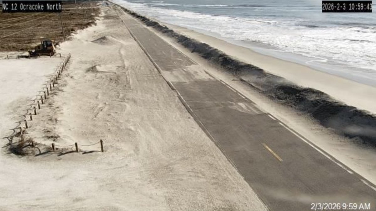
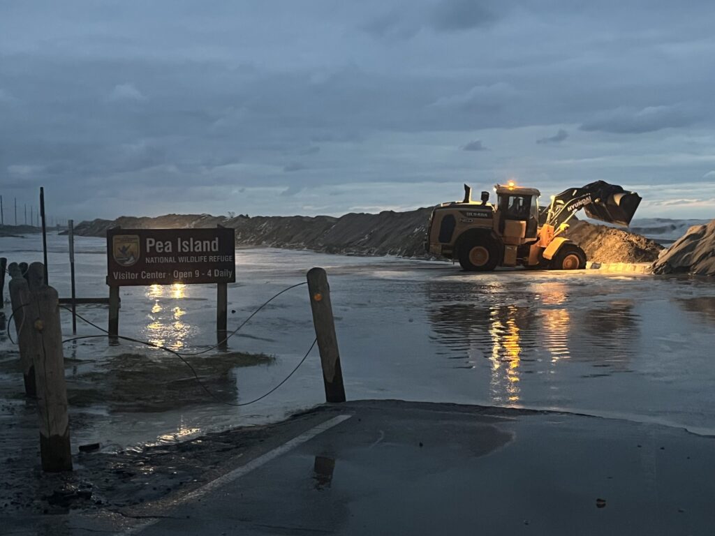
The September nor'easter East Coast threat turned concrete Thursday when North Carolina closed NC Highway 12 between Basnight Bridge and Rodanthe after overwash and road damage. An initial assessment found roughly 500 feet of pavement undermined or broken on Pea Island, severing the vulnerable route that links communities along the Outer Banks.
The same system was expected to drive coastal flooding from North Carolina toward New York through Friday, September 25, before bringing weekend wind, rain, erosion and possible power outages to parts of New England. Forecasts cited offshore waves of 15 to 18 feet near the Outer Banks.
The northern outcome remained uncertain at Thursday’s reporting cutoff. Impacts depend on how close the strengthening low tracks to the coast, where it slows and how its wind field aligns with successive high tides. One model track is not a forecast, and location-specific extremes should not be applied to the entire coastline.
Why this matters
Nor'easters are usually associated with colder months, but the September timing does not make this one harmless. Warm ocean water can feed a strengthening coastal low, while persistent northeast winds push water toward shore and into bays. Communities can face serious flooding even without exceptional rainfall.
NC 12 shows why. On barrier islands, a road is more than pavement: it is an evacuation route, supply line and connection to schools, clinics and work. Damage across 500 feet can isolate residents and force long repairs even when structures elsewhere escape major loss.
The wider risk is cumulative. Each high tide can add water before sounds, bays and tidal creeks have drained from the previous cycle. That “stacking” effect can make later flooding worse than an early forecast based on rainfall alone suggests.
Why the Outer Banks are first in line
Pea Island and Rodanthe sit on a narrow, mobile barrier-island system. Waves move sand across beaches and dunes as part of the coast’s natural evolution, but roads and houses fix people and infrastructure in that moving landscape. Overwash can bury a road; erosion can remove the sand supporting it.
NC 12 has been cut or damaged repeatedly by hurricanes and coastal storms. Repairs restore access but do not eliminate the underlying exposure. The Bonner Bridge replacement and newer elevated structures improve resilience at specific points, while long at-grade stretches remain vulnerable.
Homes near Rodanthe face the same geometry. Structures once farther from the surf can become oceanfront as the shoreline retreats. A storm does not create that long-term trend by itself; it can compress years of visible change into one tide cycle.
How coastal flooding can worsen with little rain
In the Northern Hemisphere, circulation around a low is counterclockwise. Along the Mid-Atlantic coast, that pattern can sustain northeast or onshore winds that pile ocean water against beaches and funnel it into inlets and tidal waterways.
Once elevated water enters a bay, the next question is whether it can drain before the following high tide. Persistent wind can hold it in place. The result is a sequence in which nuisance flooding becomes moderate flooding, roads stay covered longer and saltwater reaches farther inland even if local rain totals remain modest.
This is why residents should use National Weather Service coastal-flood statements for their exact zone rather than a regional rainfall map. Tide timing, shoreline orientation and local drainage can produce sharply different outcomes a few miles apart.
New England’s forecast is consequential but local
For parts of Massachusetts’ South Shore, a forecast observed Thursday mentioned 3 to 5 inches of rain, gusts up to 55 or 60 mph and waves of 15 to 25 feet. Those numbers describe a specific area and forecast window, not the entire Northeast.
A track closer to the coast would increase the chance of stronger wind, heavier rain, larger waves and power outages. A track farther offshore would reduce inland impacts but could still produce dangerous surf and erosion. Small changes in track and pressure can move the corridor of strongest wind substantially.
New England utilities may benefit from advance notice and the ability to stage crews. Coastal businesses and fishing fleets face the opposite trade-off: early closures cost income, but waiting for certainty can expose workers and equipment after conditions become unsafe.
Winners, losers and the price of repeated repair
There are no simple winners in destructive coastal flooding. Contractors and emergency suppliers may see demand, but that activity reflects damage paid by households, insurers and governments. Property owners, renters, road-dependent businesses and people who cannot easily evacuate carry the largest immediate losses.
Tourism economies can lose a weekend even if roads reopen quickly. Commercial fishers lose safe operating days. Taxpayers repeatedly fund sand replacement, road repair and emergency response. Insurers may raise premiums or narrow coverage after repeated claims, shifting more risk back to owners.
One limited benefit is better evidence for resilience planning. Each closure shows where water crosses, how long access fails and which protective measures worked. That information is valuable only if agencies use it to compare repeated repair with elevation, relocation or redesigned access.
Historical parallels—and what makes September unusual
The East Coast has a long history of damaging nor'easters, including the 1962 Ash Wednesday storm and the 1991 “Perfect Storm.” Those events differed in season, track and intensity, so neither is a template for this system. They illustrate the same structural hazard: a large, persistent wind field can batter a long coastline through multiple tide cycles.
September storms also compete with tropical systems for public attention. The label matters less than the mechanisms. Whether a low is tropical, subtropical or extratropical, onshore wind, wave energy and duration determine coastal damage.
Climate change raises the baseline from which storm tides operate as sea level rises. It does not prove that warming caused this single nor'easter or its precise track. It means a comparable circulation can reach farther inland than it would have from a lower sea level.
Three scenarios for the weekend
Closer coastal track: the low strengthens near shore, bringing the highest combined risk of wind damage, heavy rain, erosion and outages in the Northeast. Repeated tides prolong flooding, and travel disruption expands inland.
Middle track: the core remains offshore, but a broad onshore wind field keeps surf and coastal flooding dangerous. Rain and outages are more localized, while beach erosion and marine conditions remain severe.
Farther offshore: inland wind and rain fall below early high-end projections. That would not reverse damage already done on the Outer Banks, and rip currents, high surf and some tidal flooding could continue.
Evidence for each scenario will come from the observed low center, pressure trend, wind direction, tide gauges and official warning changes—not from a single dramatic model image.
What residents and officials should watch
- NC 12 inspection updates: the length of the closure depends on whether damage is confined to pavement or extends to the roadbed and protective structures.
- Successive tide gauges: water that fails to recede before the next high tide signals increasing bay and tidal-creek risk.
- Track and wind-field changes: a westward adjustment would increase coastal and inland exposure; an eastward shift would concentrate more energy offshore.
- Local utility notices: tree and line damage can occur outside the zone of deepest flooding.
- Beach access restrictions: large surf can undercut dunes and structures even when skies appear to improve.
The central judgment is straightforward: uncertainty about the northern track should narrow claims, not delay preparation. The Outer Banks already has measurable damage. Farther north, the prudent response is to prepare for the high-impact edge of local forecasts while continuing to update the expected track.
Sources and further reading
- USA Today: Mid-Atlantic impacts and New England forecast
- Outer Banks News: NC 12 damage and closure
- Fox Weather: Outer Banks surf and coastal flooding
- The Weather Channel: regional track scenarios
- National Weather Service: coastal flood information
Reporting basis: Fixed September 24, 2026 snapshot. Forecasts are location-specific and can change; follow current National Weather Service and local emergency-management instructions.