nor'easter flooding outages New York
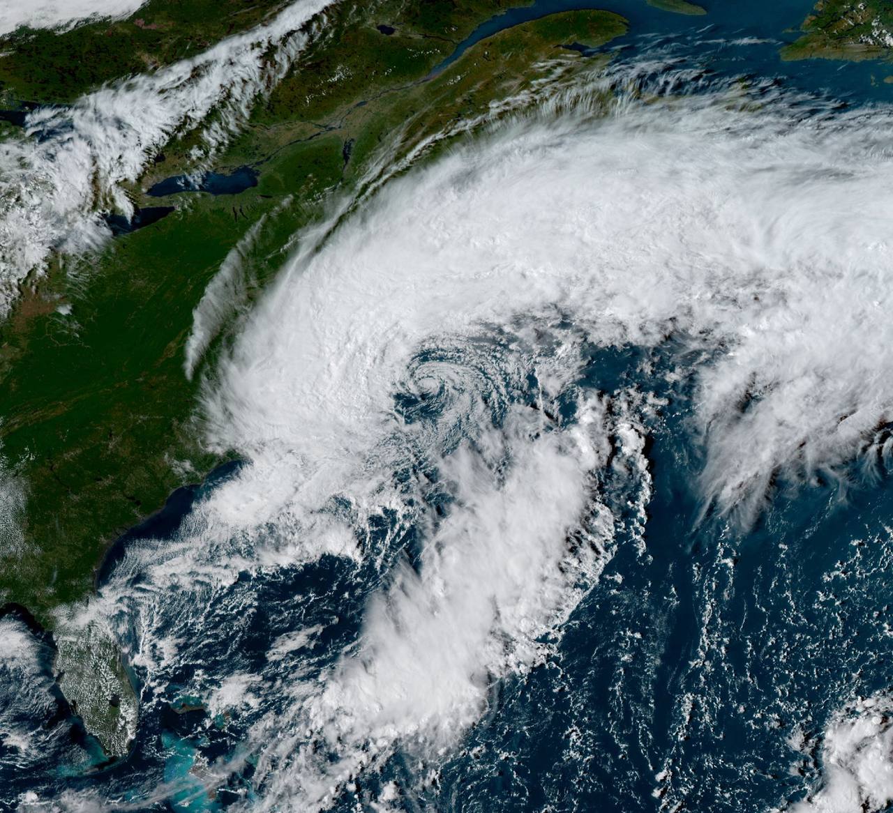
NEW YORK — The nor'easter flooding outages New York story turned deadly Saturday when a falling tree struck a 56-year-old man near 700 Euclid Avenue in East New York, Brooklyn. Police said he suffered “trauma throughout his body.” He was taken to Brookdale Hospital and pronounced dead shortly after 5 p.m., after the incident was reported at about 3:30 p.m. The New York City Housing Authority confirmed that he was a NYCHA employee but did not say whether he had been on duty.
It was the first reported death linked to a storm already testing the Northeast on several fronts. New York and New Jersey had declared states of emergency. About 100,000 customers lost power at one point Saturday. Water climbed more than three feet above normal high-tide levels in parts of New York Harbor, while Atlantic City's September 26 high tide reached its highest point since Hurricane Sandy in 2012.
The storm's reach extended far beyond one block in Brooklyn. A gust hit 81 mph at Montauk, the highest reported with the system; JFK Airport recorded 55 mph, and Wellfleet, Massachusetts, recorded 70 mph. The New York City Parks Department logged 371 reports of downed trees by Saturday evening, though many were duplicates, and sent crews onto 12-hour shifts through the weekend.
Why this matters
This was not a routine wet Saturday. Non-tropical September nor'easters account for only about 1% of nor'easters on record, and meteorologist Max Schuster said the last comparable event may have occurred around 1940. With a minimum central pressure of 986 millibars, the system combined an unusual early-season timetable with the wind field and coastal push more often associated with colder months.
Timing changed the damage profile. Many trees still carried full leaf canopies, giving strong gusts more surface area to push against. Rain-saturated soil weakened the grip of roots. That combination helps explain why falling trees and power lines became such a central hazard even away from the water. Along the coast, the Harvest Moon peaked at 12:49 p.m. EDT Saturday, producing spring tides that amplified the storm-driven rise.
A higher long-term sea-level baseline also leaves less room between an ordinary high tide and flooding thresholds. It does not create the nor'easter, but it can make the same onshore push more consequential than it would have been years earlier. With tens of millions of people in the storm's path, the event became a stress test for tree maintenance, drainage, transit, utility restoration and public warnings across multiple jurisdictions at once.
How Saturday unfolded
The official response began Friday. Gov. Kathy Hochul declared an emergency for all five New York City boroughs and Nassau, Suffolk and Westchester counties, later formalizing a State Disaster Emergency effective September 25 and authorized through October 25. Nassau County Executive Bruce Blakeman and Suffolk County Executive Edward Romaine issued emergency declarations as well. In New Jersey, Gov. Mikie Sherrill declared an emergency for Atlantic, Burlington, Cape May, Cumberland, Middlesex, Monmouth, Ocean and Salem counties.
By Saturday morning, the message had hardened. “Anyone who goes in or near the water this weekend is literally gambling with their life,” Hochul warned. At a Saturday briefing she added, “Mark my words, much more is coming,” and said the full moon could push tides higher, with waves of 20 feet in some places. Mayor Zohran Mamdani issued a travel advisory after the expected track shifted closer to New York City, bringing heavier rain and stronger winds, and urged residents to look out for neighbors.
New Jersey officials were also watching the next tide rather than treating a lull as an all-clear. Sherrill wrote Saturday that “this storm is not over” and urged residents to remain vigilant. Manasquan recommended voluntary evacuation from low-lying zones, particularly for elderly residents and people with special needs.
Then came the fatal tree strike in East New York at about 3:30 p.m. By evening, outages had spread, vehicles had been abandoned in rising floodwater in Elmhurst, Queens, and New Jersey Route 35 was closed at the Sayreville–Old Bridge border. The Long Island Rail Road suspended its Long Beach Branch between Valley Stream and Long Beach. The most dangerous coastal cycle was still ahead as Saturday night's high tide approached.
The numbers that tell the story
- 1 death: the 56-year-old NYCHA employee killed by a falling tree in East New York.
- 81 mph: the storm's highest reported gust, at Montauk; 55 mph was recorded at JFK Airport and 70 mph at Wellfleet.
- 3.54 feet: the reported storm surge at Kings Park, New York.
- 2.27 inches: Saturday rainfall at Long Beach, the highest among the listed New York-area observations. Southold recorded 2.18 inches, Eastport 2.07, Ozone Park 1.88, Upton 1.85, East Rockaway 1.69 and Brooklyn College 1.31.
- About 100,000 outages: customers without power at the Saturday peak. A midafternoon snapshot put the total near 74,700 across New York, Connecticut and New Jersey. Other state reports included about 35,000 in Connecticut, more than 31,000 in Rhode Island and more than 8,200 in Massachusetts.
- 425 cancellations and more than 1,300 delays: the disruption to flights by Saturday afternoon, as the FAA warned of weather delays at JFK, LaGuardia and Newark.
- 20-foot waves: the upper range Hochul said officials expected in some areas.
- 986 millibars: the storm's reported minimum central pressure.
Those figures describe different hazards rather than one uniform disaster zone. A person inland may have faced falling limbs and a dark house. A coastal business confronted saltwater. A traveler saw a cancellation board. The same low-pressure system translated into sharply different consequences depending on elevation, tree cover, infrastructure and timing.
Who is exposed
Basement renters and residents of low-lying neighborhoods face the fastest-moving danger when water enters streets and buildings. Coastal businesses can lose equipment, inventory and weeks of trade in one tide. Commuters depend on rail lines and roads that may close long before their own homes are threatened. Utilities must restore service while winds and fallen trees still make field work dangerous, and insurers ultimately price the repeated losses.
In Surf City, New Jersey, marina owner Kenny Formica watched surveillance cameras as water rose inside his building. It was the first time that had happened since Sandy, which caused more than $4 million in damage to his business. His experience captures the storm's uneven geography: one neighborhood may see a difficult rainstorm while a few blocks closer to a bay or tidal channel take water into buildings.
Access itself became part of the risk. Amtrak suspended all New York City–Boston service during the storm. On flooded streets in New York and New Jersey, kayakers paddled where cars would normally travel, while some residents surfed the unusually high waves despite official warnings. Such scenes can look recreational from a distance; they also show how quickly ordinary transport corridors can become waterways.
What comes next
There was no immediate reprieve in Saturday's forecast. National Weather Service lead forecaster Bob Oravec warned of “a lot of high winds, a lot of high tides and heavy rain possibility over the next few days for the northeastern U.S.” Gusts could reach 80 mph in parts of the Northeast on Sunday, and the highest tides north of Atlantic City were expected from Saturday night into Sunday. Rainfall in the New York City area could total as much as eight inches by Monday.
The immediate work is rescue, road clearance and power restoration. The next test is whether repeated tide cycles trap water in vulnerable places before it can drain. As the storm moves offshore Monday, officials will face longer questions: whether known tree risks were addressed, where drainage failed, how quickly utilities moved crews and whether warnings reached the people least able to relocate.
The storm's rarity should not be mistaken for irrelevance. A system that represents roughly 1% of the historical nor'easter record can still reveal common weaknesses. The policy question is not how to prepare for this exact storm again, but whether the Northeast's everyday systems can withstand a wider range of wind, tide and rainfall arriving together.
Sources
- Associated Press: persistent nor'easter batters the Northeast
- The Hill: New York and New Jersey declare states of emergency
- New York Post: Brooklyn man killed by falling tree
- New York Post: storm impacts across the New York City region
- lohud: New York rain totals, flooding and travel disruption
- Fox Weather: live nor'easter updates
- Men's Journal: emergency declaration and coastal flood warnings
- Wikipedia: September 2026 nor'easter event record
Reporting basis: Fixed September 26, 2026 snapshot. Fatality details are attributed to police and NYCHA reporting; outage, rainfall, wind, surge and travel figures reflect the cited reports available Saturday and may be revised. Analysis is Signal Post News's.