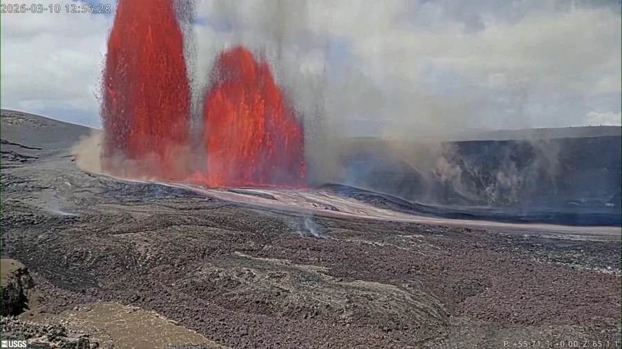
The Kilauea volcano eruption October 2026 story is best understood as a changing summit system, not a single dramatic blast. Fresh video showed lava and strong glow inside Halemaʻumaʻu, while the U.S. Geological Survey’s Hawaiian Volcano Observatory described a highly pressurized summit after a shallow magma intrusion. Nearly 100 earthquakes were recorded during the September 30–October 1 unrest, including a magnitude 3.4 event about a mile beneath the surface. Temporary closures followed around Keanakākoʻi, old Crater Rim Drive, nearby overlooks and part of the Crater Rim Trail.
As of the latest October 1 observatory account available for this report, the intrusive pulse appeared to have ended, but the volcano remained active and capable of changing quickly. Scientists saw no obvious new ground cracks or anomalous hot areas during an overflight. Lava remained deep in the north vent, and intermittent overflows and spatter had resumed in the established vent complex. The practical message is nuanced: there was no evidence of a new eruption site threatening communities, yet conditions remained favorable for another fountaining episode or passive lava from an existing crack system.
Hawaii volcano eruption today: the verified status
The USGS framework separates ground hazard from aviation hazard. WATCH means an elevated or escalating volcanic condition with increased potential for eruption, or an eruption posing limited hazards. ORANGE tells aviation users that a volcano is showing heightened unrest or is erupting with little or no ash. Those labels are serious, but they do not mean the entire island is under evacuation. Kīlauea is a large, monitored system; the location of the vent and the path of lava matter more than the word “eruption” by itself.
Most current activity has been concentrated at the summit within Hawaiʻi Volcanoes National Park. The September 30 swarm began near the active vents, then migrated northeast. USGS scientists measured about 40 microradians of rapid inflation at the Uēkahuna tiltmeter, consistent with an east-west crack opening as magma pushed into rock. More than 30 located earthquakes occurred in the first six hours, followed by over 50 in a second cluster. Seismicity and deformation then eased, evidence that the short intrusive event had slowed.
That sequence explains why “Kīlauea erupts” and “intrusion ended” can both appear in coverage. An eruption is already ongoing at the summit, with active vents and intermittent lava. An intrusion is a specific episode when magma moves into a crack underground; it may feed an existing vent, create a new one or stop before reaching the surface. The latest intrusion did not produce a detected new vent, but it altered the pressure and possible pathways inside an already active volcanic system.
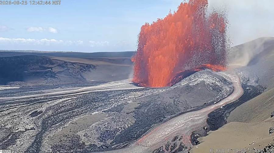
What Kilauea lava fountains reveal about the magma system
Lava fountains form when gas-rich basaltic magma rises and pressure drops. Dissolved gases expand into bubbles, accelerating molten rock through a vent. The result can look explosive, but basaltic fountaining differs from the ash-rich explosive eruptions associated with more viscous magma. Kīlauea’s magma is comparatively fluid, so gas often escapes through fountains and lava flows. Even so, fountains can throw tephra, Pele’s hair and hot fragments beyond a vent, and gas emissions can affect communities far downwind.
Between fountain episodes, vents can glow, spatter or overflow at lower intensity. That stop-start behavior reflects the relationship between magma supply, gas accumulation and conduit geometry. A fountain episode releases pressure; the system can then recharge. Tiltmeters record tiny changes in ground angle as the summit inflates and deflates, seismometers track rock fracture and fluid movement, and gas instruments measure sulfur dioxide. No single signal guarantees the timing of a fountain, which is why USGS language emphasizes probabilities and rapidly changing conditions.
The September intrusion complicated the familiar cycle. Instead of simply feeding the established vents, magma opened a shallow path beneath the summit. It may have exploited cracks left by the 2018 caldera collapse and later eruptions. Scientists saw no new thermal anomaly during the October 1 overflight, but cracks can remain hidden or inactive until pressure changes again. Monitoring is therefore an exercise in combining imperfect views: ground movement, earthquake migration, gas, heat and cameras.
Why Kīlauea is a shield volcano
Kīlauea is a shield volcano, built by many layers of relatively fluid basaltic lava that spread outward and create broad, gentle slopes. The shape contrasts with steep stratovolcanoes formed by alternating lava and fragmental deposits. The Hawaiian hotspot supplies magma as the Pacific Plate moves across it, generating an island chain whose volcanoes record that movement over millions of years.
The popular phrase “magma chamber” can imply a single underground cavern. In reality, Kīlauea’s plumbing is a connected system of storage zones, conduits, fractures and rift zones. Magma can accumulate beneath the summit, migrate laterally and erupt far from the caldera. That network explains both the frequent summit activity and the risk of flank eruptions. It also explains why scientists are careful: a vent confined to Halemaʻumaʻu presents one risk profile; migration into the East Rift Zone could create another.
Kilauea eruption history: 2018 is the essential comparison
The 2018 lower East Rift Zone eruption remains the modern warning against assuming summit activity will always stay at the summit. Magma drained from the summit and moved into the lower rift, where fissures opened in residential areas. Lava destroyed hundreds of homes, covered roads and transformed the coastline. At the summit, withdrawal contributed to repeated collapse events and dramatic enlargement of Halemaʻumaʻu. That crisis was geographically and socially different from the present summit-confined episode.
Kīlauea also erupted nearly continuously from 1983 to 2018 at Puʻu ʻŌʻō and other East Rift Zone vents. After the 2018 collapse, summit eruptions returned in late 2020 and have occurred episodically. The current sequence, underway since December 2024, has produced repeated fountain episodes separated by pauses. That history makes two points at once: frequent activity is normal for Kīlauea, and each configuration can produce different hazards.
Historical parallels should guide preparation rather than sensationalism. The 2018 disaster does not mean the same outcome is imminent. USGS stated there were no current signs that magma was migrating out of the summit region. But the observatory also noted that such migration can begin with little warning. Preparedness is rational precisely because prediction cannot remove all uncertainty.
Is Kilauea dangerous right now?
For people in closed summit areas, the answer is unequivocally yes. Cliffs can collapse, ground can crack, volcanic gases can concentrate and ejecta can fall around vents. Visitors must obey barriers even when a camera angle makes lava appear safely distant. The caldera edge was destabilized by the 2018 collapse, and earthquakes can trigger rockfalls. The National Park Service closes areas based on hazards that are not always visible from a trail.
For most residents and visitors elsewhere on Hawaiʻi Island, the immediate risk is lower and depends heavily on wind, health and location. Vog — volcanic smog formed when sulfur dioxide reacts in the atmosphere — can irritate eyes and lungs, aggravate asthma and reduce visibility. Fine volcanic glass and ash can contaminate catchment water and damage equipment. People with respiratory conditions, children and older adults may experience effects before healthy adults do.
Lava is not the only hazard. Tephra can be carried downwind; Pele’s hair consists of thin volcanic-glass strands that can irritate skin and eyes; earthquakes can unsettle slopes; and drivers may encounter reduced visibility. Hazard messages should therefore avoid the false binary of “safe” versus “catastrophic.” A community can face no lava inundation while still dealing with gas and particulate exposure.
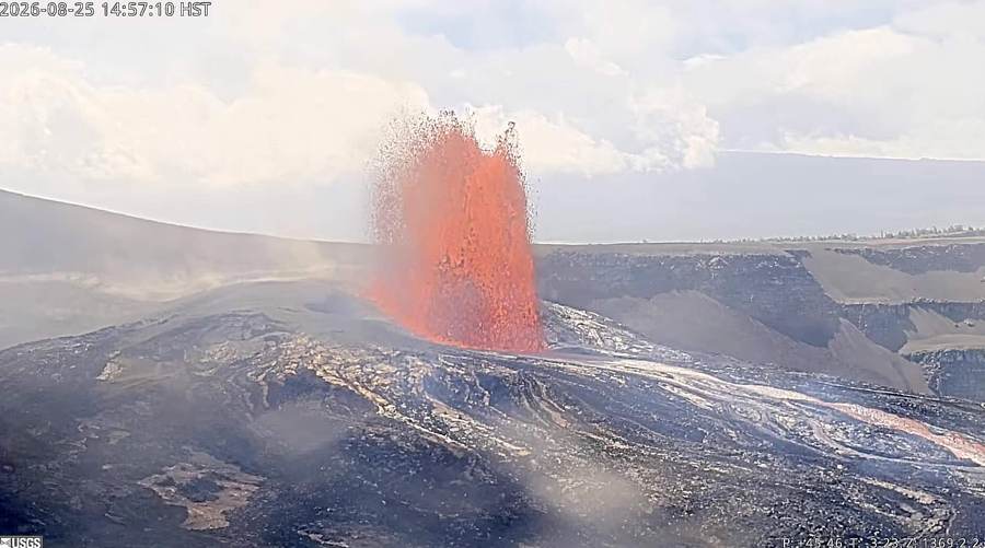
Hawaii Volcanoes National Park status and visitor guidance
Travelers should check the National Park Service alert page immediately before leaving, not rely on a social post or yesterday’s itinerary. The Keanakākoʻi area closure covered old Crater Rim Drive, nearby overlooks and the Crater Rim Trail segment to Keanakākoʻi; the Devastation Trail parking lot remained open in the latest notices cited by weather coverage. Access can change as earthquakes, gas or vent conditions shift. A viewpoint open in the morning may close later.
Use established overlooks, stay behind barriers and carry water, sun protection and a light source if visiting near dawn or dusk. Do not enter closed areas for a better photograph. Keep children close, and avoid sitting on unstable crater edges. If vog is heavy, shorten strenuous activity and move indoors or upwind. An N95 can reduce exposure to particles but does not filter sulfur dioxide gas, so a mask is not a substitute for leaving a gassy area.
Driving distances on Hawaiʻi Island are substantial. The national park is not a quick extension of a Kona beach itinerary, and nighttime return trips require planning. Visitors should fuel the car, download directions, monitor weather and recognize that emergency vehicles need clear access. Never stop in a traffic lane to photograph glow. A safe experience begins with accepting that the volcano, not the visitor, sets the schedule.
Tourism, local business and cultural respect
Eruptions can increase demand for lodging, guides and restaurants near the park, but sudden closures and alarming headlines can also cause cancellations across an island that remains largely unaffected. The winners and losers can switch within days. Licensed guides may help visitors interpret hazards and Hawaiian cultural context; unauthorized tours may pressure guests toward closed zones. Businesses benefit most when official information is clear and visitors distribute spending without treating an active landscape as an amusement ride.
Kīlauea is not only a geological attraction. Native Hawaiian relationships to the volcano, including traditions connected with Pele, carry living cultural meaning. Reporting and tourism that describe lava solely as spectacle flatten that reality. Respect includes pronunciation, place names, staying on legal paths and listening to local guidance. It also means recognizing that residents have experienced loss as well as wonder through past eruptions.
Winners, losers and the cost of uncertainty
Science gains from dense instrumentation and repeated episodes: every intrusion and fountain tests models of magma storage and eruption timing. Public agencies gain an opportunity to demonstrate risk communication before a crisis reaches homes. Visitors can witness an extraordinary natural process from managed distances. Local photographers and guides may see increased interest.
Residents with respiratory illness, outdoor workers and communities downwind bear disproportionate costs from vog. Park staff manage crowds while operating near real hazards. Travelers can lose prepaid plans when areas close. Scientists also face a communication dilemma: cautious language may sound vague, while confident predictions can fail in a complex system. The honest product is not certainty but continuously updated probability.
What to watch next
The next scenario could be another high fountain from the established north-south-west vent complex. A second scenario is passive lava from one of the new or pre-existing cracks without a dramatic fountain. A third is another intrusion that remains underground. The higher-consequence, currently unsupported scenario would be magma migration away from the summit toward a rift zone. Watch earthquake locations, rapid tilt changes, sulfur dioxide output and NPS closures for evidence that the risk map has changed.
Episode counts can be useful shorthand, but they are less important than location and intensity. A tall fountain contained in the caldera may be visually spectacular with limited off-site lava hazard; a lower-volume fissure near infrastructure can be more consequential. Readers should prioritize USGS hazard maps and civil-defense instructions over viral video.
The central lesson of the Kilauea lava fountains is that an active shield volcano can be both observable and unpredictable. Monitoring has made surprises smaller, not impossible. The right response is neither panic nor complacency: it is disciplined attention to place, wind, closures and official updates.
For related environment coverage, see Signal Post News on the East Coast nor’easter, Typhoon Dujuan’s flooding impact, and the world archive.
How officials turn instruments into an alert
Volcano monitoring is a chain of interpretation. A seismometer records shaking, but analysts must distinguish magma movement from tectonic earthquakes, rockfall, wind and human noise. A tiltmeter measures minute slope changes, but rain and instrument drift can complicate the signal. Gas measurements depend on wind and access. Thermal cameras see surface heat but not every underground pathway. Forecast confidence rises when several independent instruments point toward the same process.
That is why the September 30 sequence was important: earthquakes migrated, ground deformation accelerated and established vents changed behavior during the same window. The overflight then supplied a visual and thermal check. No new hot crack was found, narrowing the immediate possibilities without proving nothing had changed below ground. Public updates translate this evidence into conditional language because a binary prediction would misrepresent the science.
Vog preparation for residents and travelers
People sensitive to vog should follow air-quality observations and wind forecasts, keep prescribed medication available and identify an indoor space with filtered air. Closing windows may help when outdoor concentrations rise; a properly sized air cleaner can reduce particles indoors. Sulfur dioxide exposure can produce coughing, throat irritation and shortness of breath. Anyone with severe symptoms should seek medical guidance rather than treat an online air-quality map as a diagnosis.
Rain can turn volcanic emissions into acidic droplets, affecting metal, plants and catchment systems. Residents using rainwater should follow local public-health advice. Visitors in rental cars should not assume air conditioning removes volcanic gas. If conditions worsen, moving away from the plume is more effective than remaining at an overlook for a photograph.
How to read the next viral eruption video
Check the date, camera and episode before sharing. Kīlauea imagery is frequently recycled because older fountains remain visually convincing. A dramatic clip may show a previous episode with different hazards. Official camera labels and USGS timestamps provide context. Ask whether the video shows summit Halemaʻumaʻu, a rift-zone fissure or an unrelated Hawaiian volcano. Location changes meaning.
Scale is equally deceptive. A telephoto view can make a fountain appear close to an overlook, while a wide image can make a dangerous vent look small. Height estimates should come from observatory measurements, not visual guesswork. The best evidence pairs imagery with maps, instrument data and an official time. Spectacle attracts attention; context keeps that attention from becoming misinformation.
The long view
Kīlauea will continue changing after this news cycle ends. Repeated summit episodes build new lava surfaces, alter vents and test the fractured caldera floor. Some periods will be quiet enough for broader access; others will produce sudden closures. The island’s communities have learned that preparedness cannot wait for a perfect forecast. Scientists refine models, park staff adjust access and residents make practical decisions under uncertainty.
For outsiders, the discipline is to resist turning every fountain into either apocalypse or entertainment. Kīlauea is an active natural system embedded in communities and culture. Its October unrest deserves attention because pressure, earthquakes and lava changed together. It deserves proportion because the observed hazard remained concentrated at the summit. Holding both truths is the foundation of useful volcano reporting.