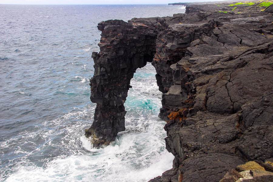
The Hōlei Sea Arch collapse has erased one of Hawaiʻi Volcanoes National Park’s most recognizable coastal landmarks. The 90-foot, or 27-meter, arch was still standing on Wednesday, September 23, when the park temporarily closed during Tropical Storm Nolo. When the park reopened on Monday, September 28, visitors and staff found open ocean where the rock vault had stood for roughly 550 years.
Park officials believe the arch was gone by Sunday night, September 27, but the exact moment remains unknown. That uncertainty matters: Nolo brought strong winds, heavy rain and high surf after weakening from a Category 4 hurricane, yet the National Park Service has not said a single wave or gust can be identified as the direct cause. The more defensible conclusion is that a heavily fractured structure, already weakened by earthquakes and repeated surf, reached its final threshold during the storm closure.
“Yes, it’s true. RIP Hōlei Sea Arch,” the park said in social posts before issuing an official October 1 news release. The agency described the loss as the latest transformation of a coastline that is never fixed, however permanent it may appear in photographs.
Why this Hawaii landmark’s destruction in 2026 matters
A landmark formed over centuries can disappear between one park closure and the next. That is the central fact behind the public shock: the arch’s human life as a viewpoint and travel icon was long, but its geological life was temporary. The National Park Service had said so plainly before the fall: “This formation is beautiful, but temporary, and has a limited life span.” Its description continued, “The sea arch will eventually crumble into the sea. However, others will replace it as the cliff slowly migrates inland.”
The collapse is therefore not evidence that normal geology suddenly stopped behaving normally. It is evidence of how gradual weakening and acute weather can intersect. Pacific coastal erosion in Hawaii works day after day, exploiting cracks and softer rock. A tropical cyclone adds higher surf, rain and wind over a shorter period. When a structure is already close to failure, the final event may look instantaneous even though the conditions that made it possible accumulated for decades.
Nolo’s former Category 4 intensity also puts storm risk in focus, but it would be misleading to use one fallen arch as proof of a trend in cyclone strength. What the event does show is exposure: places built from fractured volcanic rock face repeated wave attack, and stronger surf events can accelerate losses that park geologists already expect. The lesson is about compounding hazard, not a claim that the arch would have stood indefinitely without this particular storm.
How a Kīlauea lava arch formed through differential erosion
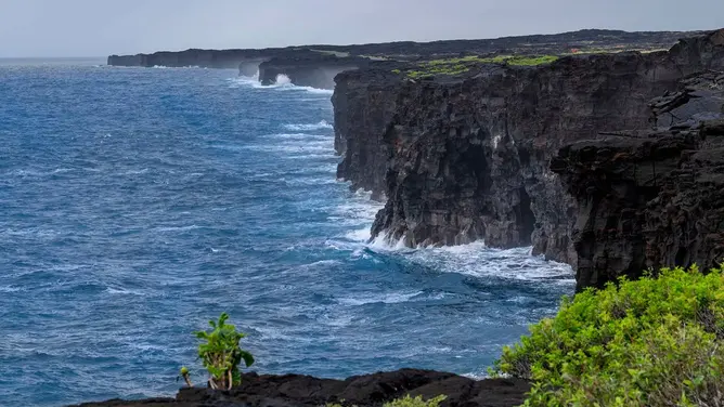
The Hōlei Sea Arch in Hawaiʻi Volcanoes National Park began with lava rather than water. About 550 years ago, flows from Kīlauea reached the southern coast in the Kaʻū District and hardened against the sea cliffs. The Pacific then did the sculpting. Waves forced water and air into joints in the rock; weaker layers and fractured material wore away faster than the more resistant lava above and beside them.
Geologists call that process sea arch formation by differential erosion. It first opens a notch or cave, then enlarges it until a bridge of harder rock remains. The same forces continue after the opening exists. Every wave that passes through the vault also attacks its supports, so formation and destruction are stages of one process, not opposites.
The coordinates — 19°17′40″N, 155°05′53″W — place the former arch at the end of Chain of Craters Road, where the route drops from Kīlauea’s summit region through old lava fields to the coast. Its name came from Hōlei Pali, the escarpment on the volcano’s slopes. For generations of park visitors, the arch was a visual endpoint: a black volcanic span set against white surf, reached after a drive through a landscape made by repeated eruptions.
That setting made it more than a scenic object. The arch condensed the park’s story into a single view — Kīlauea built the rock, the ocean excavated it, and the same ocean eventually removed it. The USGS had used Hōlei as a teaching example years before the collapse, warning that waves were eroding the pillar every day and that “one day, it will be gone.”
The warning signs: 2018 fractures, a 2020 closure and 2022 swell
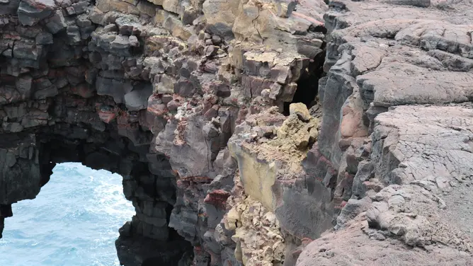
The final collapse did not arrive without warning. Earthquakes during Kīlauea’s 2018 eruption and summit collapse damaged coastal cliffs near Hōlei. In January 2020, new cracks and visible instability led the park to close the original viewing area. A safer viewpoint opened farther back in March, reducing the need for visitors to approach the edge.
Heavy surf then removed more rock. The park’s October 1 release noted that Tropical Storm Darby’s massive surf broke away a lower chunk later in 2020. Reporting on the arch’s recent history also documented a large loss during a historic south swell in 2022. By then, photographs from different years showed substantial changes in the supports and cliff face.
Those events form a clear sequence: volcanic earthquakes opened or widened weaknesses; the park moved people away; repeated high surf enlarged the damage; and Nolo arrived at a coast already recognized as unstable. None of that allows scientists to timestamp the final fracture, but it explains why the collapse was expected even if its date was not.
Hurricane Nolo and Hawaii: what happened during the closure
Nolo had weakened from a Category 4 hurricane by the time its outer effects brushed the island chain, but that did not make it harmless. The system delivered strong winds, high surf and heavy rain to Hawaiʻi, with flash flooding and road closures reported on the Big Island. Hawaiʻi Volcanoes National Park closed on September 23 as the tropical storm approached and remained shut through the dangerous weather window.
The arch stood when that closure began. It was absent when access resumed on September 28. Park officials believe the collapse occurred by Sunday night, September 27, during the period when staff and visitors were away from the coastal viewpoint. That timeline makes Nolo the immediate weather context, though not a proven single trigger.
Signal Post News had tracked Hurricane Nolo’s threat to Hawaiʻi Island before the storm. The arch’s loss now provides a tangible measure of what coastal hazard can mean even when the worst forecast scenario does not materialize across populated areas.
Visitor safety after the Hawaii sea arch collapsed
The vanished landmark has created a new danger: people approaching the old viewpoint to see what remains. The National Park Service said photos on social media showed visitors entering the closed area near the former arch. Officials warned that doing so puts both visitors and first responders at risk of falling and drowning along a rough, wave-swept coast.
These are not theoretical warnings. Four people have fallen to their deaths from the cliffs in this area during the past decade. The edges can “drop off vertically into the ocean and present a serious falling hazard,” the park said. Cracks may extend beneath apparently solid ground, and a cliff can fail without the visual cues people expect before a collapse.
The proper viewing distance is therefore set by closures and barriers, not by how stable the edge looks from above. Visitors should stay on open routes and use the designated setback. The loss of the arch does not make the remaining cliff safer; it confirms that the entire margin is active and changing.
What happens next along Chain of Craters Road
The National Park Service has not announced whether it will install a permanent marker at the former arch site. Any decision will need to account for safety, the changing shape of the cliff and the fact that the old viewing area had already been moved back. In the near term, the agency’s priority is keeping people out of the closed zone.
Geologically, the story continues. As the sea cliff retreats inland, waves will probe new cracks and weak layers. Caves will open; some may become arches; pillars may separate into sea stacks; and those formations will eventually fall too. The agency’s prediction that “others will replace it” is not a promise that a new arch will appear quickly or in the same place. It is a description of the coastline’s long cycle.
The loss also sits beside Kīlauea’s continuing changes inland. Readers can follow the latest Kīlauea volcano unrest and park restrictions, or compare Nolo’s impacts with Hurricane Polo’s landfall and flood hazards in Baja California. Together, those stories show a region where volcanoes, storms and ocean erosion operate on different clocks but can reshape familiar places with little notice.
Hōlei Sea Arch will remain in family photographs, park archives and geological lessons. On the ground, however, the view has already become something else — not an empty version of the old landscape, but the next stage of the same volcanic coast.
Sources
- National Park Service: Hōlei Sea Arch Collapses in Hawaiʻi Volcanoes National Park
- CNN: Hawaii’s famed Hōlei Sea Arch has collapsed
- New York Post: Hawaii’s iconic Hōlei Sea Arch collapses into ocean
- Fox Weather: Centuries-old Hōlei Sea Arch collapses after Nolo
- U.S. Geological Survey: Hōlei Arch and differential erosion